


Pax, WV (West Virginia), a community in southwestern Fayette County, in southern West Virginia, was incorporated in 1920 and named for Pack's Branch, a tributary of Paint Creek. Though predominantly rural in character, it sits astride a busy interstate expressway that continues to increase its economic viability.
Regional tourism initiatives and infrastructure development projects are boosting its potential as a residential and commercial center with an industrial component. The town is popularly known as a bedroom community of the nearby city of Beckley.
History
The valley at Pax had been inhabited by several prehistoric cultures as early as 12,000 years ago, though permanent settlements might not have been established until about 1000 B.C. Burial mounds, petroglyphs, and other earthworks have been found throughout the immediate area. Habitation by indigenous peoples in villages appears to have been usual until the late 1600s, after which the expanding Iroquois nation to the north pressured many to leave the region. Native peoples continued to visit the area, traveling through on ancient trails until the adoption of the Treaty of Greenville in 1795, after which all native claims to land in the region east of the Ohio River ceased.
The first permanent settler of European descent at Pax was William Humphrey, who raised a cabin near the mouth of Willis Branch on Paint Creek in the late 1820s and established a grist mill. Humphrey acquired thousands of acres, which he bequeathed to his children. Coincidentally, two of his descendants, Howard Hughes and his son, William Hughes, have recently served as mayors of Pax. William Hughes is currently mayor.
The community that became Pax was first known as Paintsville, presumably as a result of its location on Paint Creek or near the "Painted Trees" for which the stream was named.
Growth commenced in earnest in about 1902, when the Deepwater Railway was completed from the Kanawha Valley south through the Paint Creek valley to the Virginia line. In 1907 the line was extended to the Atlantic Coast as the Virginian Railway, bringing interstate commerce to the community. In 1910 a branch of the Kanawha, Glen Jean, & Eastern Railway (KGJ&E) was extended from the New River coalfield west to join the Virginian at Pax. Coal mining boomed in the region as the railroads opened, and though it was not a mining town, the industry greatly supported Pax's growth and commerce.
The town was incorporated as Pax in 1920, though the origin of the name remains obscure. It may be an abbreviation of "Packs," as the community is located at the mouth of Pack's Branch on Paint Creek. It may also be associated with the Latin word for "Peace."
The West Virginia Turnpike was completed through the valley of Paint Creek in 1954, opening the community to modern interstate commerce.
An estimated 631 persons resided in the town in 1940 when its population was at its peak. Its population was estimated at 167 in 2010 by the U.S. Census Bureau.
The Paint Creek Warpath
A prehistoric village of indigenous peoples was located near the present-day town where two important warpaths joined, including the legendary Paint Creek Trail. Warriors traveling the trail would ritually paint trees along the creek with red pigment to represent their victims. A larger grove of painted trees was located at the mouth of Willis Branch near the present expressway exit; a smaller grove, at the mouth of Sand Branch.
Lodging near Pax, West Virginia
Parks & Recreation
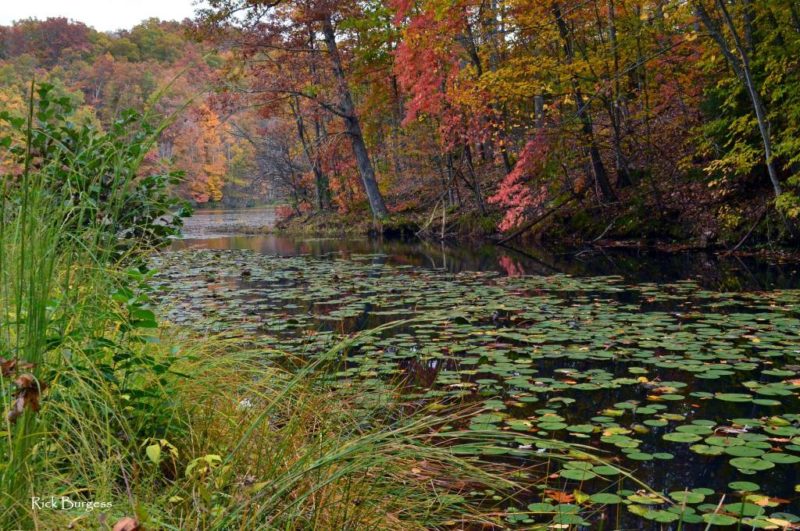
Plum Orchard Lake Wildlife Management Area is located five miles northwest of Pax, and the Paint Creek Scenic Trail travels along the Paint Creek through the community. The Paint Creek is an important West Virginia trout stream and is stocked at Pax in spring.
Pax is also the southern terminus of the developing New River Gorge regional trail network, which leads through the wildlife management area to the New River Gorge National Park and Preserve, and Gauley River National Recreation Area to the Monongahela National Forest at Richwood, West Virginia.
Location
Pax is located on expressways I-64 and I-77 approximately six miles north of Mossy, West Virginia, and 13 miles north of Beckley, West Virginia. Packs Branch Road (Fayette County Route 27) provides an alternate seven-mile rural route between the expressway at Pax and the US-19 expressway at Mount Hope, West Virginia.
Packs Branch Road is also a popular alternate route of access for the Bechtel National Scouting Reserve near Mount Hope.
Pax's location along the expressway has made it particularly desirable for residents in search of rurality with fast access to city amenities.
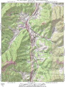
Map of Pax, West Virginia
Longitude: -81.2644
Latitude: 37.9097
Regional Information
Pax is located in the New River Gorge Region of southern West Virginia near the Metro Valley Region.


