


Lost village of “Lilly” hides in national park lands in West Virginia
HINTON, W.Va. — Deep in a forested gorge where the Bluestone River winds, the lost village of “Lilly” was among southern West Virginia’s first frontier communities.
The landscape today only hints at a small settlement that had a mighty impact. It was the home of the progenitors of the Lilly, Meador, and Meadows families, who together account for more than 3,000 residents in the region. The annual Lilly reunion drew more than 75,000 in 1941, according to the Washington Post, and was considered the world’s largest family reunion.

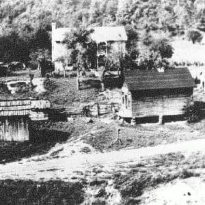
The farmstead of Robert and Fanny Lilly is long gone. (Photo courtesy William Sanders)
Though the village vanished when federal flood-control projects took control of the land in the 1940s, its story endures in part through the research of the late historian William Sanders, a country gentleman lawyer who spent decades documenting the history of Lilly, West Virginia, with the help of other local historians.
I joined Sanders in the late 1990s to walk the remains of the old village, which then included only crumbling foundations. What looked like an untouched wilderness became, through his eyes, a layered archaeological record. “People lived here, farmed here, worshiped here,” he said while we surveyed a bench above the river. “Lilly isn’t gone. You just have to know where to look for it.”
Frontier Families Carve a Settlement
The history of Lilly begins around 1800, when Robert and Mary Frances “Fanny” Moody Lilly settled in the Bluestone Valley, along with Josiah Meador II, a Revolutionary War veteran. They built their homes near the junction of the Bluestone and Little Bluestone rivers, a fertile area of bottomland through which ran an old Indian trail. The land around was rugged and mountainous, but full of old timber and wildlife.
Robert Lilly had come from the Back Creek region of Botetourt County, Va., near present-day Roanoke, where he operated a mill. Some traditions trace the Lilly line to French Huguenot ancestry. Meador, who fought at Yorktown and served in the Bedford militia, moved west after the war with his wife, Judith Lilly, the daughter of Robert and Fanny Lilly.
Their arrival marked the beginning of an extended settlement that grew around intermarried families. Three children of the elder Josiah Meador married three children of Robert and Fanny Lilly, producing a dense circle of kin that later expanded into Mercer, Summers, Raleigh, and Fayette counties. Sanders described the valley as “a web of families so tightly connected that nearly everyone was a cousin.”
A Mountain Village Takes Shape
By the mid-19th century, the settlement had developed into the village of Lilly, a community of roughly 50 families. It straddled early roads that would later become Ellison Ridge Road and Sand Knob Road and supported farms, homesteads, and several small mills.
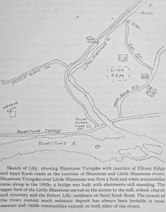
A hand-drawn map by William Sanders notes the placement of buildings and cemeteries at Lilly.
A Primitive Baptist congregation, founded in 1798 by Meador, became one of the village’s central institutions. Early services were held in Meador’s home before a dedicated church was built. The congregation, renowned for its strict adherence to Baptist tradition, played a significant role in cultivating a rich religious life throughout the Bluestone and New River regions.
A school and post office served the surrounding hollows. Families farmed terraces above the rivers, and mills processed grain and lumber. The Bluestone itself provided transportation, power, and, occasionally, destruction. Floods swept through the valley often enough that families accepted the river as both lifeline and threat.
Military Service and Frontier Duty
The families who settled at Lilly left a significant military legacy. Meador fought in the Revolutionary War, and his descendants later served in frontier militia companies. Edmond Lilly, son of Robert and Fanny, fought in the War of 1812 and is commemorated with a government marker.
Letters, pension documents, and early county records provided Sanders with much of the genealogical detail now used to reconstruct the history of Lilly, West Virginia. He often drew on such documents to trace the families to earlier settlements in Botetourt, Bedford, and Essex counties in Virginia.
The End of Lilly
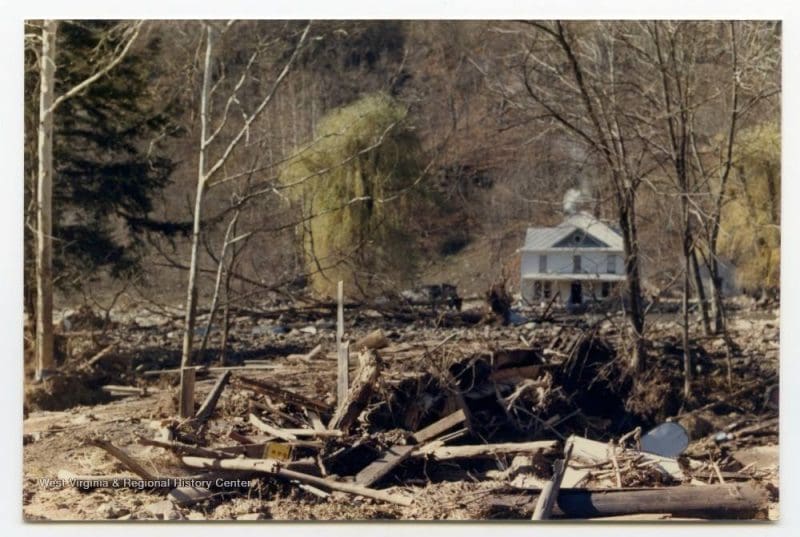
The decisive turning point in Lilly’s history occurred in the 1930s and 1940s, when the U.S. Army Corps of Engineers initiated construction of the Bluestone Dam on the New River. The dam was designed to prevent catastrophic flooding downstream, but required the acquisition and clearance of the Bluestone Valley above Hinton.
Lilly stood directly in the inundation zone. Residents were forced to leave, and homes, mills, and outbuildings were dismantled or abandoned. Some families relocated to higher ground. Others moved out of the county entirely.
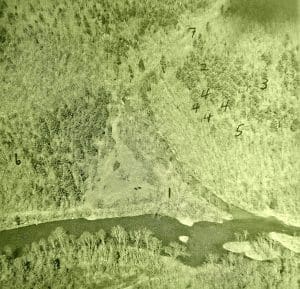
An aerial photo provided by Sanders designates 1.) Josiah Meador Store, 2.) Church, 3.) School, 4.) Lilly Cemetery, 5.) Robert Lilly Residence, 6.) Meador Cemetery, 7.) the Turn Hole.
One of the most difficult tasks involved removing the community’s cemeteries. Sanders interviewed residents, including Beecher Meadows, who supervised the disinterment. In many cases, only fragments could be recovered after a century in rocky soil. “It was heartbreaking work,” Meadows told Sanders. “But it had to be done.”
Remains from 149 graves were exhumed from Lilly Cemetery, with most reinterred in Crews Cemetery on Sand Knob near Nimitz. Robert and Fanny Lilly were reinterred at the Lilly Reunion Grounds at Flat Top.
By the late 1940s, after the last structures had been razed and the last graves relocated, the valley filled with the rising waters of Bluestone Lake. The village of Lilly disappeared, its foundations submerged beneath the reservoir and its former roads reduced to faint traces in the forest.
The Bluestone National Scenic River
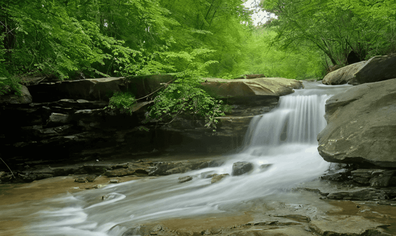
Although the village was lost, the land did not vanish into obscurity. In 1988, Congress designated a 10.5-mile stretch of the Bluestone River as the Bluestone National Scenic River, thereby placing much of the former village site under the protection of the National Park Service. The preserve runs between Bluestone Dam and the confluence at Pipestem, following a corridor that has long been used by the Lilly family.
Today, hikers along the Bluestone Turnpike Trail pass near the sites of homesteads, orchards, and family burial grounds without realizing it. The National Park Service maintains the trail and manages the surrounding wilderness, ensuring that the valley retains much of the natural character the original settlers would have recognized — steep ridges, deep shade, the sound of water over stone.
Sanders believed the federal designation was an unexpected gift. “The land is protected now,” he said. “It won’t be developed. In a way, Lilly has become part of our national heritage.”
A Historian’s Lifework Preserves the Story
In 1989, Sanders compiled his research into “Lilly on the Bluestone,” a 58-page booklet that remains the most comprehensive historical account of the settlement. Only 1,000 copies were printed, and fewer than 50 remain in circulation.
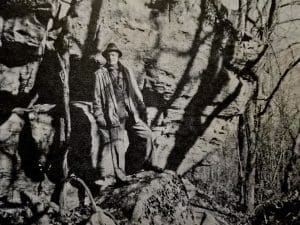
Historian William Sanders visits Clay’s Rocks near Gravely Point, where settler Mitchell Clay camped. (From “A New River Heritage,” Vol. 2)
The volume includes genealogies, early land records, and personal narratives that illuminate life in the valley. One account describes Elizabeth “Betsy” Lilly, who, at the age of 14, planted a pine tree on her grandparents’ graves. Another recounts an 1812 letter from William Lilly, written from the Louisiana Territory, describing frontier dangers along the Mississippi.
Sanders’ work preserves names and stories that otherwise might have been forgotten. His research continues to guide genealogists, historians, and descendants seeking to understand the history of Lilly, West Virginia.
Legacy of a Vanished Community
While no buildings remain and the village cannot be excavated, its influence endures in the families who trace their ancestry to the Bluestone Valley and in the landscape now preserved as a national scenic river.
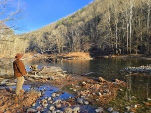
The writer explores the Bluestone River at the mouth of the Little Bluestone River. (Photo courtesy Yvonne Reed Wilcox)
The story of Lilly reflects the broader history of Appalachian settlement—a history shaped by migration, faith, family ties, conflict, and the eventual collision between local communities and federal flood-control policies.
“Lilly isn’t just a place on a map,” Sanders said during our visit nearly three decades ago. “It’s the story of people who built a life here, lost it to larger forces, and left behind a legacy that still matters.”
Today, as the Bluestone National Scenic River protects the valley where the town once stood, the history of this lost community remains accessible to anyone willing to walk the trails and imagine the bustling mountain village that once filled the gorge.
Lilly Reunion Continues the Tradition
For many descendants, the primary link to the vanished village is the annual Lilly Reunion, considered one of the oldest continuous family reunions in West Virginia. The gathering brings together hundreds of relatives from across the country to share genealogies, preserve oral traditions, and honor the families who settled the Bluestone Valley. For many attendees, it is the only opportunity to reconnect with distant cousins whose ties trace directly back to the lost settlement.
Lilly Monument at Flat Top Honors the Families
The region’s heritage is also commemorated at the Lilly Monument near Flat Top, where a stone marker and landscaped overlook pay tribute to the families who lived in the valley before the construction of Bluestone Dam.
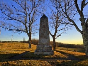
The remains of Robert and Fanny Lilly were reinterred at Flat Top, West Virginia, beneath a stone obelisk on the Lilly Reunion grounds. (Photo: David Sibray)
The monument, situated near the Flat Top entrance to the Bluestone National Scenic River, has become a pilgrimage point for descendants. It stands not only as a memorial to the vanished village but also as a reminder that its people—their history, labor, and legacy—remain an integral part of West Virginia’s cultural landscape.
Learn More
Visitors interested in exploring the Bluestone National Scenic River, the Lilly Monument, or regional history are encouraged to contact the Summers County Convention and Visitors Bureau at Explore Summers County for travel information, trail guidance, and interpretive resources. Google coordinates for the former townsite are 37.58391768973001, -80.97164369456468.

Inside Appalachian Escapes: Themed rentals, escape rooms, and a love letter to West Virginia
FAYETTEVILLE, W.Va. — What began as a search for an affordable retirement option has turned into one of southern West Virginia’s most imaginative...
West Virginia bottler wins silver award at international water competition
BERKELEY SPRINGS, W.Va. — Le Sage Natural Water, of Lesage, has been awarded a silver medal for its purified water at the 36th annual Berkeley...
West Virginia uniquely prepared to dominate 21st-century outdoor economy
CHARLESTON, W.Va. — West Virginia is uniquely prepared to dominate in the 21st-century outdoor economy of the U.S., thanks to its unmatched...
Flood risk outpaces warnings, advocates say, as W.Va. considers changes to resiliency fund
CHARLESTON, W.Va. — As the W.Va. House of Delegates considers changes to Senate Bill 390, the West Virginia Rivers Coalition warns that the state...
We asked AI how its own data centers could pollute West Virginia. Here’s what it had to say
(The following article was generated partly by ChatGPT in response to a prompt about how data centers pollute. As ChatGPT is powered by data...
Inaugural W.Va. Outdoor Economy Summit to unite leaders around $2.1 billion growth
CHARLESTON, W.Va. — West Virginia’s outdoors are more than a scenic backdrop. They’re a strategic economic asset. That message will take...
West Virginia State Parks Foundation launches online merchandise store
HURRICANE, W.Va. — The West Virginia State Parks Foundation has launched an official online merchandise store, offering supporters a new way to...
West Virginia Travel Safety: What it means for residents and visitors in 2026
CHARLESTON, W.Va. — Travel safety in West Virginia is shaped less by headline-grabbing crime and more by geography, weather, and the realities of...
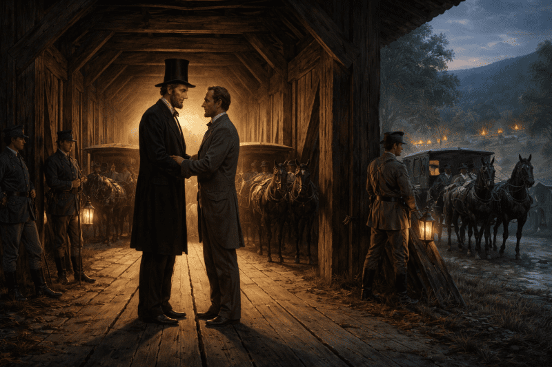
Did Abraham Lincoln and Jefferson Davis secretly meet in West Virginia?
PHILIPPI, W.Va. — Did Abraham Lincoln and Jefferson Davis secretly meet in what is now West Virginia just days after the first land battle of the...
Study finds WVU and its health system account for 17% of West Virginia’s economy
MORGANTOWN, W.Va. — West Virginia University and the WVU Health System together generate $14.3 billion in annual economic impact in West Virginia,...