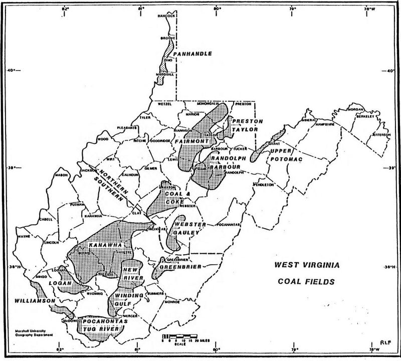
The New River Coal Field is the name used to describe a coal-producing section of West Virginia that includes the following counties, in whole or in part: Fayette and Raleigh counties. Having no transportation system, the New River field was largely defined by the routes taken by the railroad lines that first reached the area during the 1870s.

Coal Seams of the New River Coal Field
The seams of the New River Coal Field lie in the New River group of the Pottsville series. Of these, the Sewell and the Fire Creek seams have been the major producers, although some coal was obtained from the Beckley seam in the region around Beckley.
Development of the New River Coal Field
Even before the completion of the Chesapeake & Ohio Railway (C&O) in 1873, between Richmond, VA and Huntington, WV, at least three coal operations were preparing to ship coal from mines located along the C&O mainline through the New River Gorge. The first shipment of coal from the New River field occurred in September 1873, the coal being shipped by Joseph Lawton Beury via the Chesapeake & Ohio Railway from a mine located near the present-day site of Quinnimont, WV, in Fayette County. That same year, the mines at Hawks Nest and Nuttallburg began shipping coal. By 1876, the mines at Sewell, Caperton and a mine operated by George Straughan were opened. The mine at Fire Creek opened in 1877. By 1885, the mines at Beechwood, Gaymont, Stone Cliff and Beury were shipping coal.
All of the early mines in the New River Coal Field were located in Fayette County. The first mine in Raleigh County opened in the New River Coalfield was the mine at Royal, which opened in about 1890 or 1891. The development of the coal lands of Raleigh County was slowed due to the area’s lack of a rail line. For about thirty years after completing its rail line, the C&O was reluctant to fund the building of branch lines into coal-rich lands in the highland areas above the gorge. As a result, most of the early branch lines railroads built from the 1870s through the early 1900s were financed totally, or in part, by the landowners.
The expansion of the New River Coal Field in the plateau areas above the New River Gorge had begun even prior to the completion of the C&O line. In 1870, a narrow-gauge railroad was built from along the C&O line at Hawks Nest up along Mill Creek to a mine near Ansted. The narrow-gauge line was completed within a few months of the completion of the C&O rail line in 1873. By the early-1900s, the branch line railroads in the New River Coalfield included: Mill Creek Branch, from Hawks Nest to Ansted; the South Side Branch, from South Side Junction to Bridge Junction; a narrow-gauge railroad line from Sewell to Clifftop; Rend Branch, from Thurmond to Minden; Keeney’s Creek Branch from Nuttallburg to Lookout; Loup Creek Branch from Thurmond to present-day Mount Hope; Laurel Creek Branch, from Quinnimont to Layland; and Piney Creek Branch, from Prince to Beckley.
Loup Creek and White Oak Coal Fields
The Loup Creek and White Oak coal fields of Fayette and Raleigh counties were developed during the late 1800s and early 1900s as railroad lines began to be built in the yet undeveloped coal lands of the New River Coal Field along Dunloup Creek and White Oak Creek. The Towns of the Loup Creek and White Oak Coal Fields section provides more detailed information about the mining towns and coal operations in the Loup Creek and White Oak fields.