
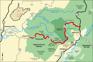
MARLINTON, W.Va. — Traveling through a remote, windswept landscape of spruce and cranberry, a scenic parkway that explores some of the highest elevations in West Virginia is attracting more visitors as tourism in the Mountain State increases.
The Highland Scenic Highway is now among the most popular scenic routes in the Mountain State, and it's growing more popular as a destination by the year, especially in the last two years, according to area officials.
Cara Rose, former executive director of the Pocahontas County Convention and Visitors Bureau, says the increase is hardly surprising in light of the recent increase in tourism in the mountains.
"There are many more visitors coming to Pocahontas County now, and that's likely to continue for years to come," Rose says, "and while I don't have traffic counts specifically for the highway, I can confirm that we're seeing more motorcycles and more cars with bikes and kayaks."
The increase was bolstered by the COVID-19 pandemic, which prompted many tourists to avoid crowded arenas and events and turn to the sparsely populated Appalachian mountains. This ignited a renewed interest in West Virginia.
"Hotel tax is up 18 percent in Pocahontas County, there are more visitors on the Greenbrier River Trail, there are more mountain bikers at Snowshoe Mountain—and there are generally more outdoor recreation enthusiasts coming to the region," Rose said.
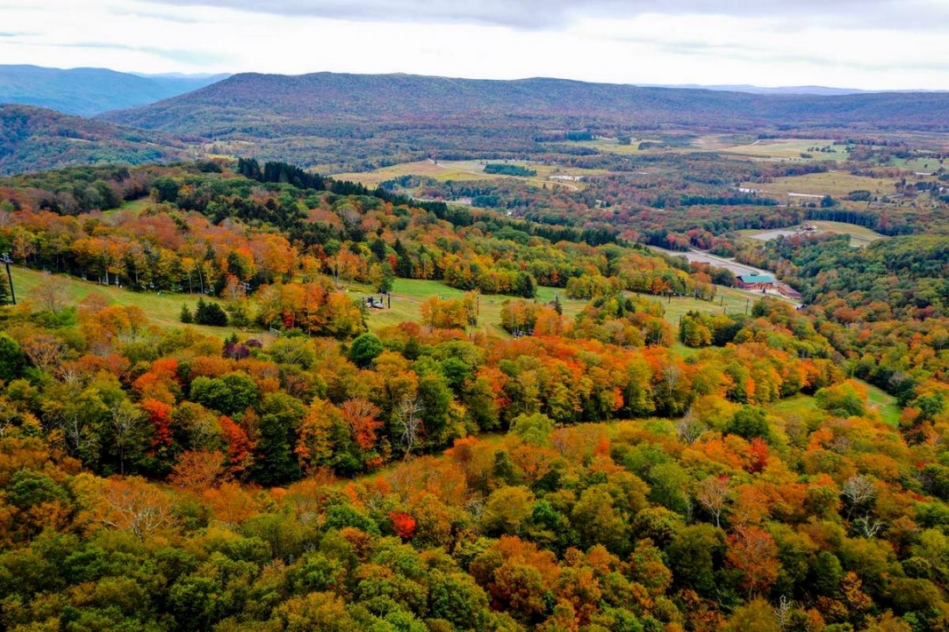
Tina White, a former public affairs specialist for the surrounding Monongahela National Forest, says the 43-mile parkway allows travelers to explore a landscape they might not otherwise experience. Many other high reaches in the Alleghenies are inaccessible except on foot.
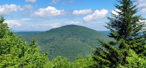
The parkway, which ascends into the Yew Mountains, a subset of the Allegheny Mountains, also allows visitors to explore a variety of highland environments without walking far from the car—cranberry glades, spruce forests, and the highest waterfall in the state.
“It’s a scenic area,” White said. “It’s remote. I think that at 43 miles, it’s a short section of road to drive to have such an abundance of scenery and opportunities to recreate.”
For those who prefer to stay in the car, the forest service offers an audio tour that travelers can listen to while driving along the parkway.
Cranberry Mountain Nature Center
An ideal staging area for a tour of the parkway, the nature center includes new exhibits and activities for children. The facility is open daily from May to October, on weekends in April and November, and is closed from December to March.
The Falls of Hill's Creek
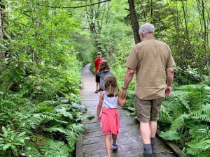
Three scenic waterfalls tumble out of the highlands as Hills Creek descends from the Yew Mountains toward the Little Levels of the Greenbrier Valley at Hillsboro. The three-quarter-mile trail that descends the stream and returns will require some exertion.
Cranberry Glades
One of the most popular natural areas in the state, the Cranberry Glade Botanical Area includes a wheelchair-accessible walkway that leads visitors through a cranberry bog inhabited by rare plants. Trails lead from the botanical area into the adjoining Cranberry Wilderness.
Scenic Overlooks
Four scenic overlooks line the highway. The Big Spruce, Little Laurel, Williams River, and Red Lick overlooks afford panoramic views off the parkway. These overlooks also have restrooms, picnic areas, and information panels.
Other noteworthy stops along the highway include Summit Lake and Honeycomb Rocks.
Plenty to see and do on the Highland Scenic Highway
White says she likes to stress to visitors that the Highland Scenic Highway provides access to a spectrum of activities that do not require exertion. However, the highway does lead through some extreme environments and trails that require experience.
More than 150 miles of trail are accessible from the parkway, including some trails that may be suitable for mountain biking or horseback riding.
“For a lot of folks, it’s important knowing it’s an area where there’s something for everyone,” White says. “It may be that people feel like hiking might be more difficult or too difficult for them. There are great, easy, gentle, beautiful trails along the highway, too.”
One of White’s favorite trails is the Red Spruce Knob Trail, just under a mile and a half, featuring the titular red spruce and moss for which the high elevations in the state are renowned.
“It has a very magical feel. It’s a beautiful area to go for a short walk,” she said.
The highway is also a popular destination for anglers. Summit Lake and the Cherry, Cranberry, and Williams rivers allow fishing and are stocked with trout and other game fish species.
Several backcountry areas along the highway, including the Cranberry Backcountry, Cranberry Wilderness, and the Tea Creek area, are perfect for those seeking a backpacking experience.
“Not everybody wants to go deep into the backcountry, but many people do,” White said. “I like that there’s so much diversity regarding skill level.
“You could go on a short hike with your family out to one of the much shorter trails that are easier, but you also have longer trails in the backcountry for somebody who wants to get into it and go backpacking or stay back more of an extended period and wants something more strenuous."
The difference in elevations along the drive is another source of adventure, White says. Some sections of the highway have cooler air, while low-lying areas such as Cranberry Glades will feel warmer. The elevation along the route rises from 2,325 feet above sea level to more than 4,500 feet.
While the Highland Scenic Highway is beautiful year-round, especially as a fall colors destination, White said the highland section of the highway (Forest Route 150) is not maintained in the winter and advises travelers to avoid that section.
“While it might be a good place if we get lots of snow to slip on your skis for cross-country skiing, it might not be a place you want to plan to drive,” she said. “So we definitely have alerts and warnings about that in winter.”
Sign up to receive a FREE copy of West Virginia Explorer Magazine in your email weekly. Sign me up!
Which overlook along the highway was the 3rd image taken with the caption "The Yew Mountains rise to more than 4,500...."