
HILLSBORO, W.Va. — Hill's Creek in eastern West Virginia is more than just a pretty stream. Though its waterfalls have won fame worldwide, scientifically speaking, there's more to the stream than meets the eye.
Descending from the Allegheny Mountains in Pocahontas County, its triple waterfalls attract thousands of tourists annually and are among the most visited scenic locales in the 921,000-acre Monongahela National Forest.
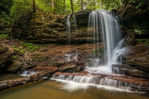
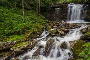
Within the 114-acre scenic area that surrounds the "Falls of Hills Creek," a three-quarter-mile trail provides visitors with access to observation areas that overlook three consecutive waterfalls, which drop 25, 45, and 63 feet over a 220-foot descent.
The observation areas for the first two falls are most easily accessible. The first fall may be reached by a paved trail that leads 1,700 feet from a parking area upstream. The third fall, however, which is the second-highest waterfall in the state, requires that visitors descend a strenuous route that includes 382 stairs.
The round-trip walk takes an hour—or longer if you plan to rest and contemplate. The area is renowned for its spring wildflowers, of which more than 40 species have been surveyed.
Beyond its beauty, however, the creek's geology and hydrology draw naturalists to the natural area and the mountains and valleys beyond, where at least four principles of stream development are demonstrated over its six-mile course.
Stream Piracy at Hill's Creek
At some point in recent geologic history, Hills Creek extended its headwater by eroding into the upper drainage of the Cherry River, capturing part of that river's flow. Hydrologists refer to this as stream piracy. Piracy is also imminent near Cass, where Leatherbark Run, a tributary of the Greenbrier River, will similarly capture the headwaters of the Shavers Fork.
The Allegheny Escarpment
Hills Creek drops precipitously down the Allegheny Front, an escarpment that extends some 400 miles along the high eastern edge of the Allegheny Plateau in Maryland, West Virginia, and Pennsylvania. Other streams along the front drop over similar ledges, though the falls on Hills Creek are more substantial because the piracy upstream has infused the creek with far more water.
Differential Erosion
In its swift descent, the middle course of the creek cascades through alternating layers of softer and harder rock. Hard sandstones erode less quickly and create the upper edges of the three falls. Softer shales eroded into long drops without falls. The hard sandstones also form the high crest of the Allegheny Front, along which the highest summits in the state are located.
Disappearance
Most small streams drain into more significant streams that drain into rivers. But Hills Creek disappears into a cavern. Hydrologists believe it sinks into the darkness beneath Droop Mountain and enters the Greenbrier River at some undiscovered point. Many streams in the region sink into the network of limestone caverns that extends 100 miles from Union to the sources of the Greenbrier River.
Visiting the Falls of Hills Creek Natural Area
The Falls of Hills Creek Natural Area is accessible year-round, though icy conditions can make access difficult in winter. Even in summer, sunlight is limited in the steep, narrow ravine, and the stairs and trails to the falls can be slippery.
Photographers should be aware that direct sunlight reaches the waterfalls only briefly during mid-day and that in summer, the waterfalls may diminish to only a trickle, though they are briefly rejuvenated after heavy rains
Visitors to the falls shouldn't miss the opportunity to visit the nearby Cranberry Glades Botanical Area, a drive of about six miles from the natural area, or the Cranberry Mountain Visitor Center, open Thursdays through Mondays from 9 a.m. to 4:30 p.m. mid-April through mid-October.
The natural area is a drive of approximately an hour north of I-64 at Lewisburg, an hour east of the US-19 expressway at Summersville, and two hours south of the US-49 expressway at Elkins.
For more information, visit the official scenic area page online or contact the Gauley Ranger District at 304-846-2695.
West Virginia trail leads through a garden of strange rocks

Wherever you turn in West Virginia, you’ll find remarkable rocks. Some may appear bizarrely unnatural. One garden of boulders in the mountains of Pocahontas County seems so unnatural that it’s hard to believe human hands haven’t carved their surfaces. Geometric forms—cones, trapezoids, and deep-pocketed triangles—cover their surfaces in places, creating lattices and honeycomb patterns that won the boulder field “Honeycomb Rocks.” READ THE FULL STORY HERE.
Sign up to receive a FREE copy of West Virginia Explorer Magazine in your email weekly. Sign me up!

Very good read Sir.
I live here on the Greenbrier & Pocahontas County line and as a local I know where Hills creek comes out of Droop Mountain.
Look on a Map and if you extended Hills Creek in a straight line through Droop Mountain you will come across Locusts Creek.
This creek pops out of a huge cave in the side of Droop Mountain and continues in the same line that Hills Creek was following for a few Miles until it runs into the Greenbrier.
They haven’t stocked Locusts creek in years but you can still catch the trout they stock in Hills Creek from Locusts Creek if you can beat the Otters to them.
I'd love to get back in there. I don't know the area well enough.