
CHARLESTON, W.Va. — Heavy rain can quickly turn West Virginia’s normally quiet creeks and rivers into destructive torrents, a danger that again confronts parts of the Mountain State as flash flooding threatens communities this weekend.
The danger is hardly new. West Virginia’s steep mountains, narrow valleys and dense network of streams have produced some of the most destructive floods in Appalachian history. In one notorious case, human failure turned that natural vulnerability into a catastrophe.
From the Buffalo Creek Disaster, which killed 125 people in 1972, to the extraordinary rainfall that devastated communities in 2016, floods have repeatedly reshaped towns, altered public policy and left lasting scars across West Virginia.
The following five disasters stand among the worst for their loss of life, destruction and lasting impact.
1. Buffalo Creek Flood of 1972 — West Virginia’s deadliest flood disaster
Death toll: 125 | Homeless: approximately 4,000 | Cause: Coal-waste impoundment failure
On the morning of Feb. 26, 1972, a coal-waste impoundment on Buffalo Creek in Logan County failed after heavy rain, unleashing approximately 132 million gallons of water and coal waste into the narrow valley below.
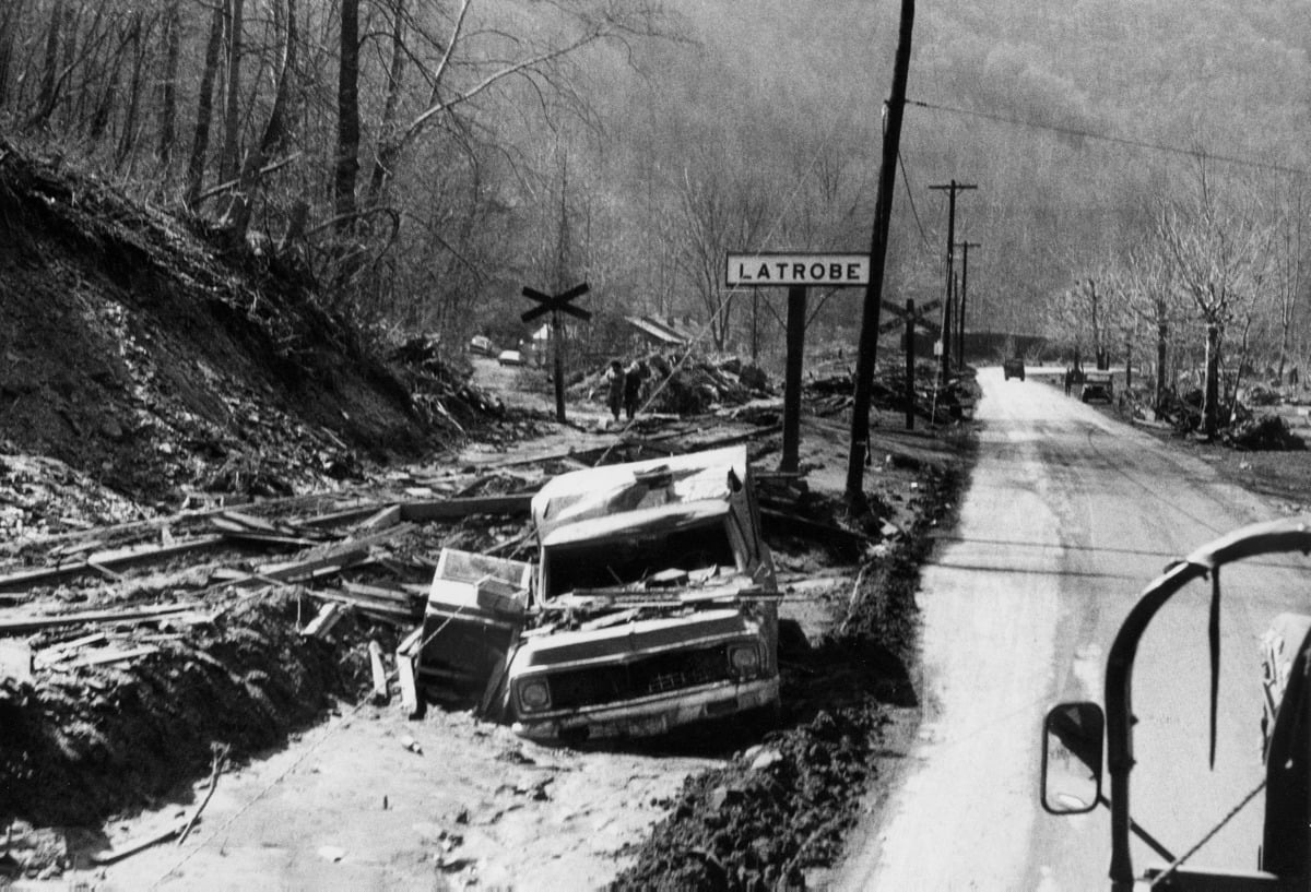
The wall of black water and debris swept through a succession of mining communities along Buffalo Creek, killing 125 people and leaving approximately 4,000 homeless. Hundreds of homes were destroyed, and entire communities were devastated within minutes.
Unlike most of West Virginia’s great floods, Buffalo Creek was not simply a natural disaster. The failure of the impoundment, operated by a subsidiary of the Pittston Coal Company, made the catastrophe a national symbol of the dangers associated with coal-waste dams and raised profound questions about industrial responsibility, government oversight, and dam safety.
The Buffalo Creek Disaster remains the deadliest flood-related catastrophe in West Virginia history, according to the West Virginia Encyclopedia.
2. Election Day Flood of 1985 — rivers rise to record levels
Death toll in West Virginia: 47 | Damage: approximately $1.2 billion
On Nov. 4–5, 1985, prolonged rainfall on already saturated ground caused catastrophic flooding across much of eastern and north-central West Virginia.
The Cheat, Greenbrier, Little Kanawha, Tygart Valley, and other rivers rose dramatically, while communities including Parsons, Rowlesburg, Philippi, Marlinton, Glenville, Petersburg, and Moorefield suffered severe damage.
At Parsons, the Cheat River crested about 10 feet above flood stage and four feet above its previous record. At Philippi, the Tygart Valley River reached nearly 15 feet above flood stage. The South Branch of the Potomac at Moorefield also set a record.
Forty-seven people died in West Virginia, with Pendleton and Grant counties suffering particularly heavy losses. Damage was estimated at approximately $1.2 billion, making the 1985 disaster the state’s most damaging flood at the time.
The catastrophe became widely known as the Election Day Flood because its worst effects occurred as West Virginians were going to the polls.

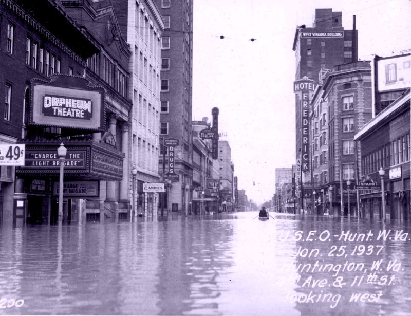
3. Ohio River Flood of 1937 — Huntington goes underwater
Crest at Huntington: 69.45 feet | Cause: Repeated winter storm systems
In January 1937, one of the Ohio River’s greatest floods inundated communities along West Virginia’s western border.
Repeated storm systems brought prolonged precipitation to the Ohio River watershed. By Jan. 28, the river at Huntington reached a record 69.45 feet — more than 19 feet above flood stage.
Large portions of Huntington were submerged, forcing residents to travel by boat through flooded neighborhoods. Communities elsewhere along the Ohio also suffered extensive damage as the river overwhelmed low-lying areas.
The volume of water was extraordinary. Near Ashland, Kentucky, immediately downstream from West Virginia, the Ohio’s discharge was measured at approximately 690,000 cubic feet per second, or roughly 446 billion gallons per day.
The disaster spurred major flood-control projects along the river, including the construction of Huntington’s floodwall, permanently changing how communities along the Ohio prepared for high water.
4. West Virginia Flood of 2016 — extraordinary rain devastates mountain communities
Death toll: 23 | Homes and businesses destroyed: more than 1,500
On June 23, 2016, thunderstorms repeatedly moved across central and southeastern West Virginia, dumping extraordinary amounts of rain over the same watersheds.
White Sulphur Springs received 8.29 inches of rain in 24 hours, more than twice the community’s previous one-day rainfall record. Nearby Lewisburg received about eight inches.
The effects were catastrophic. Flash flooding along small streams gave way to flooding on larger waterways. The Meadow River inundated Rupert and Rainelle; the Cherry River swept through Richwood; the Elk River flooded Clendenin and Clay; and Howard Creek surged through White Sulphur Springs.
Twenty-three people died, most in Greenbrier County and the Clendenin area of Kanawha County. More than 1,500 homes and businesses were destroyed, and another 2,500 sustained significant damage.
The 2016 flood became one of the deadliest natural disasters in modern West Virginia history and demonstrated how quickly extreme rainfall can become catastrophic in the state’s narrow valleys.
5. Little Kanawha Flash Flood of 1943 — 15 inches of rain in two hours
Death toll: 23 | Cause: Extraordinary localized thunderstorms
During the night of Aug. 4–5, 1943, an exceptionally intense thunderstorm struck a relatively small area of central West Virginia.

The affected region was only about 50 miles long and 10 miles wide, yet rainfall in some locations may have reached an astonishing 15 inches in two hours.
Water poured into small tributaries of the Little Kanawha River basin, sweeping through narrow valleys before many residents could escape. Twenty-three people were killed, all of them living along small streams.
The storm was so localized that conventional rain gauges failed to capture its true intensity. Investigators from the U.S. Weather Bureau, U.S. Army Corps of Engineers, and West Penn Power Company later interviewed residents and examined water collected in buckets, tubs, jars, and other open containers to reconstruct how much rain had fallen.
The 1943 disaster remains a striking example of one of West Virginia’s greatest flood hazards: a violent thunderstorm need not cover a large area to produce deadly flooding.
Why does West Virginia flood so quickly?
Geography helps explain why flooding has been such a persistent threat in West Virginia.
Much of the state consists of steeply dissected mountains and plateaus carved by thousands of streams. Rain falling on hillsides can drain rapidly into small creeks, which converge in narrow valleys where many West Virginia communities were historically built.
This pattern is especially dangerous in small watersheds. An intense thunderstorm concentrated over a relatively small area can send water rushing downstream with little warning.
Large rivers behave differently. Major floods on waterways such as the Ohio and Potomac are more often associated with prolonged rainfall, repeated storm systems, or snowmelt across much larger drainage basins. Water accumulates more slowly, but the enormous size of those watersheds can produce prolonged and widespread flooding.
West Virginia therefore faces two related but distinct hazards: sudden flash floods on small mountain streams and larger river floods that can inundate communities across broad regions.
Why the 2016 and 1943 floods were so dangerous
The 2016 and 1943 disasters show the particular danger extreme rainfall poses over small watersheds.
In 1943, as much as 15 inches may have fallen in just two hours. In 2016, thunderstorms repeatedly moved across the same areas, a phenomenon sometimes called “training,” producing extraordinary rainfall before the first water had time to drain away.
Mountainous topography then accelerated the runoff.
Water descending steep slopes became concentrated in creeks and tributaries, while homes, businesses and roads on the relatively level valley floors stood directly in its path.
This combination of extreme rainfall, steep terrain and development along streams helps explain why seemingly modest waterways can become deadly in a remarkably short period.

Flooding remains a threat across West Virginia
The great floods of 1937, 1943, 1972, 1985, and 2016 occurred under very different circumstances, yet together they illustrate a danger that remains part of life in the Mountain State.
Buffalo Creek demonstrated the potentially catastrophic consequences of dam failure. The Ohio River flood showed the enormous power of flooding across a large watershed. The 1943 and 2016 disasters showed what concentrated thunderstorms can do to small mountain streams, while the 1985 flood showed how saturated ground and widespread rainfall can push multiple river systems to record levels at once.
They also changed West Virginia. Floodwalls were built, dam safety received greater scrutiny, warning and emergency-response systems improved, and communities repeatedly reconsidered how to rebuild in flood-prone valleys.
Yet the geography that contributed to these disasters has not changed. Thousands of West Virginians still live, work, and travel along rivers, creeks, and narrow hollows where water can rise rapidly.
The danger continues. Recent analysis has found that flooding accounted for 19 of 23 federally declared disasters in West Virginia between 2011 and 2024, affecting every county in the state.
Related: West Virginia’s deadliest disasters—10 tragedies that changed U.S. history
The lesson of the state’s worst floods is therefore not simply historical. In West Virginia, understanding how water moves through the mountains can still be a matter of life and death.
Two things we know: Increasing CO2 and CH4 in the atmosphere is warming the planet, and for every degree celsius the atmosphere warms, it is able to hold 7% more moisture. These are not political opinions, they are scientific facts. And given that the atmosphere has warmed 1.75 degrees celsius during the Industrial Age, we can conclude that the atmosphere is holding at least 10% more moisture. We have no frame of reference for how these increases are affecting weather patterns, and computer models can only tell us so much, but the impact is increasingly obvious and accelerating. I suspect that heavy downpours, when they occur, will trend toward more catastrophic. You may as well get used to it, now that Donald Trump is reliquishing any leadership on climate change.
Don’t build or live on the water. Just listen to the song by Robin Lane and The Chart Busters……..”Solid Rock”……on You Tube.
Check the records for the 1916 Cabin Creek flood. Over 70 killed but many said it was over 100.