
BURNING SPRINGS, W.Va. — Practically inaccessible for years, one of the state’s legendary rock formations is attracting the attention of hikers and other intrepid sightseers.
Though the journey to the “Devil’s Tea Table” may require visitors to climb a steep slope and drive a vehicle that can ford small streams, the payoff is rewarding, and local tourism businesses are celebrating the addition to the region’s attractions.
“I think that’s fantastic,” Jerry Bain said of access to the tea table. As the president of the Country Roads Coalition, he and other members are working to support the maintenance of rural roads in the state that also serve as tourist attractions.
“This part of the state, in particular— in Wirt, Roane, Ritchie, Calhoun, and adjacent counties—benefits from an incredible network of gravel roads, and places like the Devil’s Tea Table help make touring them an even better experience.”
Calyn Ashby, owner of Midway Diner and Boggs’ Gas Station in downtown Elizabeth, West Virginia, said she is enthusiastic about the number of people touring the region.
There’s so much untapped potential in Wirt County,” she said, referencing the potential of sites such as the tea table and resources such as the Hughes and Little Kanawha rivers.
“I love when customers stop in from out of town and enjoy chatting with them about where they’re from and what they think of our small town.”
She says local businesses are poised to benefit significantly from the region’s tourism development.
“My husband and I never get tired of the amazing views our home has to offer. We pack the kids into our side-by-side and adventure all day long, taking in the views and swimming in the rivers and streams. Wirt County, along with several areas in the surrounding counties, is a hidden paradise with so much to explore.”
What is the Devil’s Tea Table?
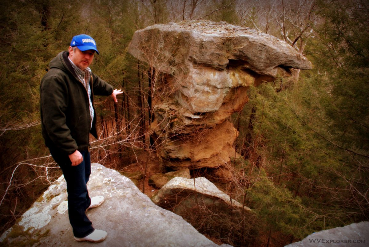
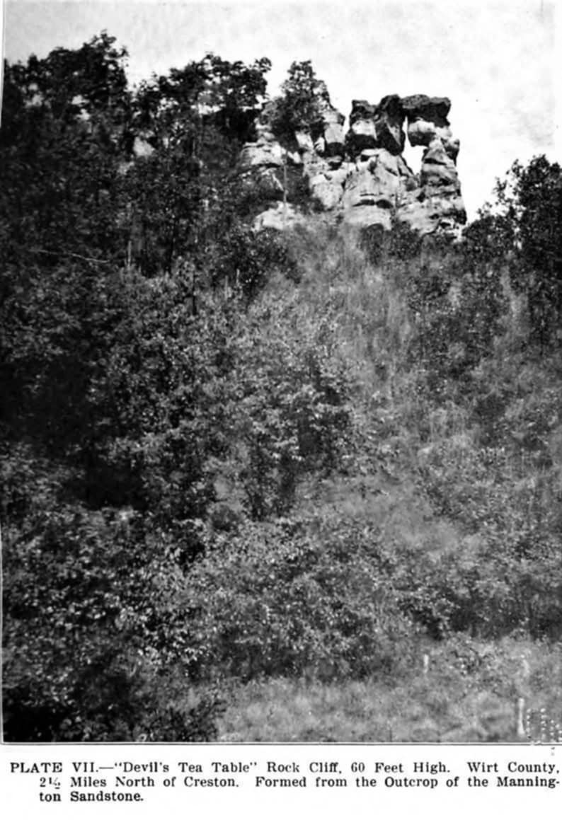
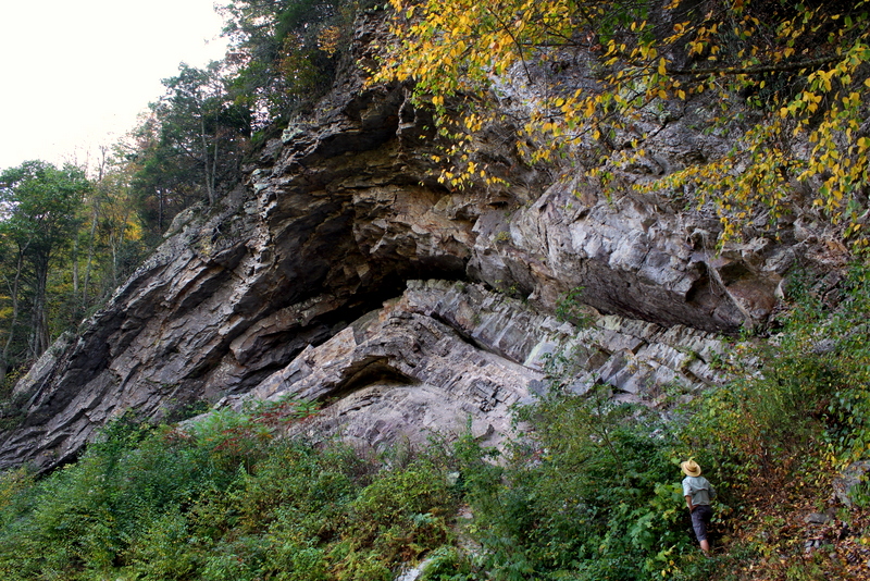
The Devil’s Tea Table is an elaborate cliff that ends in a pedestal rock, often referred to as a tea table or mushroom rock. The harder rock at the top of the pedestal is significantly larger than the column of rock that supports it. Hence, they are known as tea tables, which often consisted of a round table top on a spindly center leg.
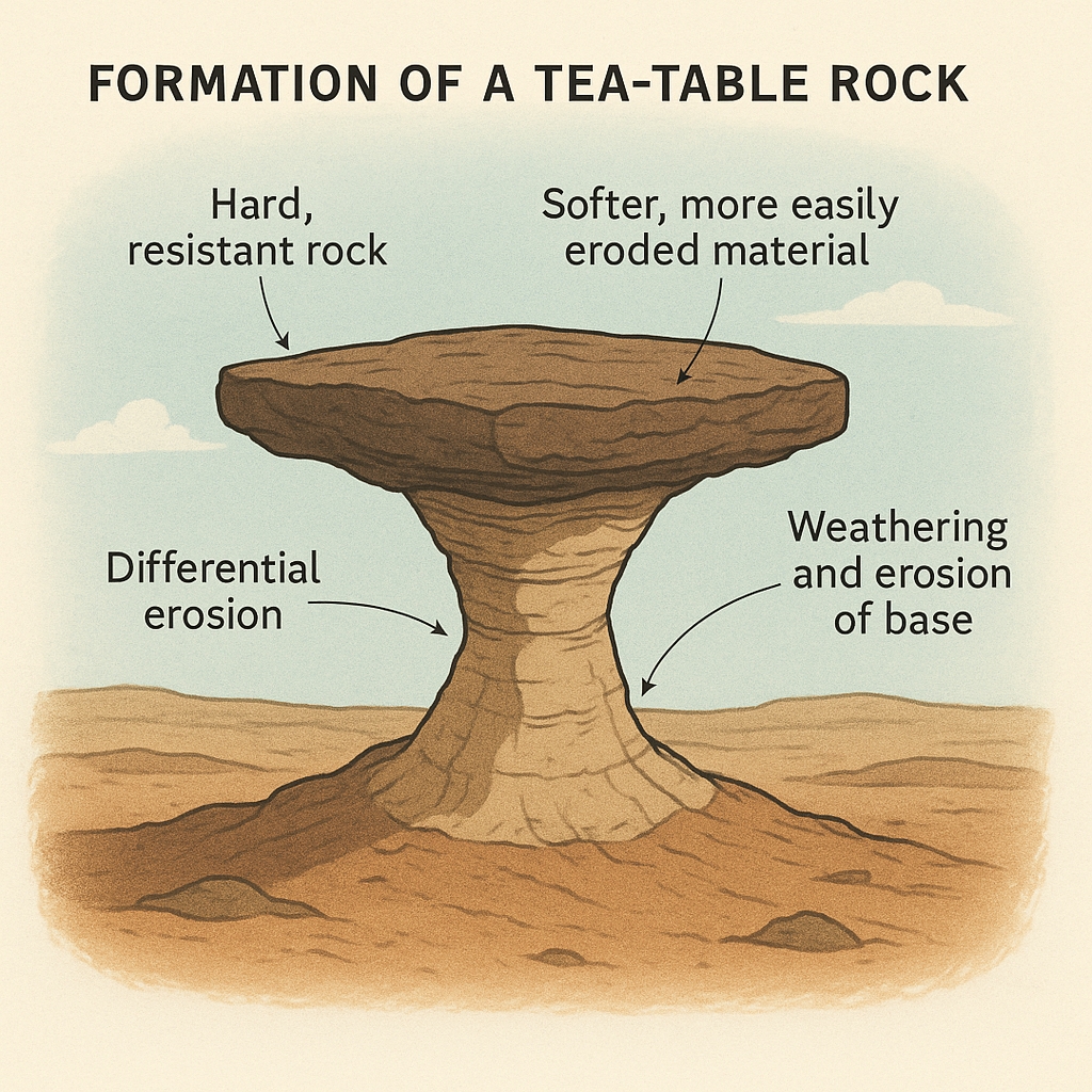
The geologic processes that create a tabletop over time are somewhat complex and rely on the combination of weathering and the hardness and softness of rock layers. The tabletop is usually a hard rock that resists weathering. Beneath it, softer rock that is being protected against weathering by the table top, but is still slowly eroding and will eventually collapse.
English-speaking settlers who knew of such rocks often attributed their formation to the supernatural or the Devil. German settlers called them “Teufelstisch.” The French called them “La table du diable.” Many are located throughout the world, and in West Virginia, there are many.
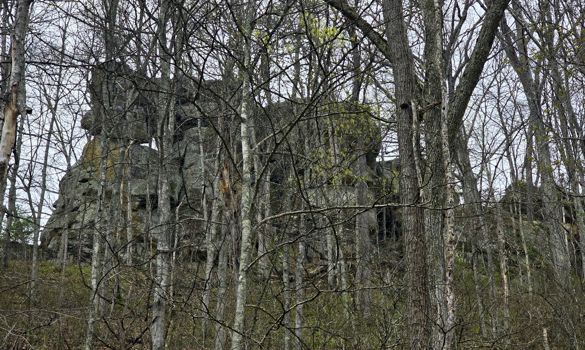
In the case of the Devil’s Tea Table at Burning Springs, the tea table was weathered from the Mannington Sandstone, which here caps the end of a ridge about the Little Kanawha River where it is joined by aptly named Rock Run. Unlike similar formations, which consist of a single table, here at the Devil’s Tea Table, several cluster.
The table is one of several natural wonders in the region, including the Burning Spring itself, where natural gas bubbled up through a pool of water and, if lit, would flame for an extended period.
Bain said that a local preacher in the years before the Civil War would light the pool during evening sermons and use it to significant effect in discussing the finer points of damnation. “It must have been something to witness,” he said.
The spring eventually attracted the attention of entrepreneurs, including John Rathbone and his sons, who in 1840 developed a thriving oil empire that was destroyed during the Civil War by Confederate troops. (Read: Civil War era mystery of Burning Springs remains unsolved)
According to geologist Nick Schaer, Burning Springs and the Devil’s Tea Table were among the many natural wonders in the immediate area that would have been known to the indigenous peoples who inhabited and visited the region.
“I think it is a given that this structure was known by native populations,“ Schaer said of the tea table.
“They certainly knew of Burning Springs and built ceremonial structures in the area. You are near the terminus of the anticline, where the upwelling deep fluids are more brine-rich. This aspect drew native use and the Rathbone family.“
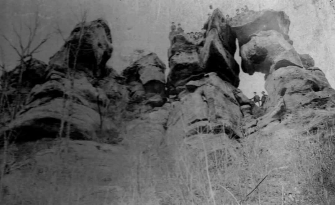
As settlers of European descent arrived in the region in the late 1700s, they quickly discovered the tea table and made regular ventures there. Many picnics were held atop the rock, and many Sunday school hikes were destined to arrive there. In the early 1900s, a local preacher hosted a sermon atop it that attracted more than a thousand spectators.
According to an article in a Parkersburg, W.Va., newspaper, the event was a bit of a spectacle:
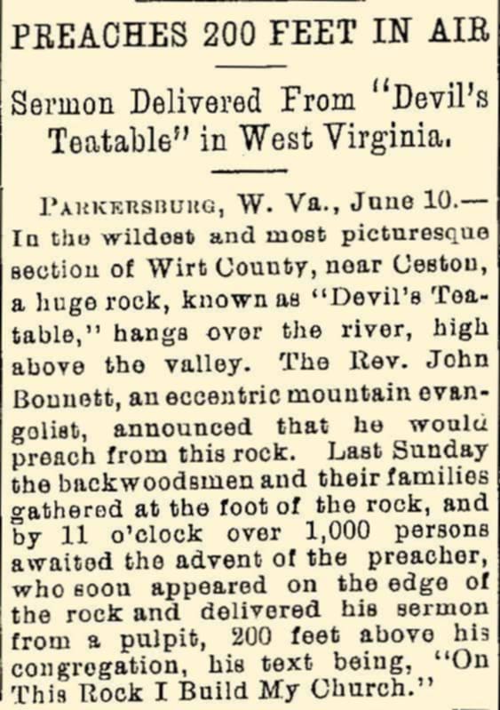
“In the wildest and most picturesque section of Wirt County, near Creston, a huge rock, known as the ‘Devil’s Tea-table,’ hangs over the river, high above the valley. The Rev. John Bonnett, an eccentric mountain evangelist, announced that he would preach from this rock. Last Sunday the backwoodsman and their families gathered at the foot of the rock, and by 11 o’clock over 1,000 persons awaited the advent of the preacher, who soon appeared on the edge of the rock and delivered his sermon from a pulpit, 200 feet above his congregation, his text being, ‘On This Rock I Build My Church.'”

Though locals continued to visit the formation, the property eventually came to be owned by MeadWestvaco, a paper manufacturer, which harvested the surrounding forests and did not allow public access. In 2020, however, the property was transferred to the West Virginia Division of Natural Resources, and public access is again allowed.
How do I get to the Devil’s Tea Table?
The Devil’s Tea Table at Burning Springs is relatively difficult to access, and visitors should take care not to arrange a visit during hunting seasons. The Little Kanawha River Wildlife Management Area, in which it is located, is preserved specifically for public hunting and fishing. Hiking, kayaking, and wildlife observation are encouraged. Camping is not accommodated.
Also, be aware that the surrounding treetops often occlude views from the rock throughout much of the summer and fall.
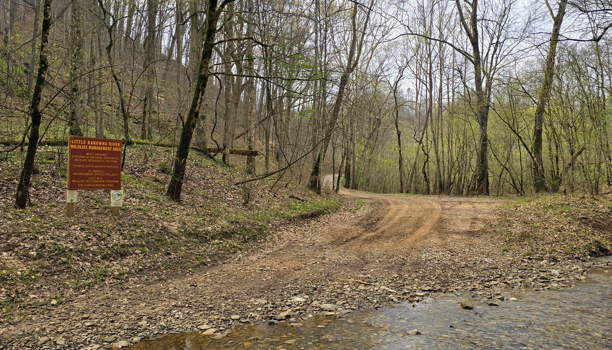
You’ll need to use a high-clearance vehicle. The gravel road that follows the river through the management area—often designated as Burning Spring-Straight Creek Road (Wirt County Route 34)—travels over several rocky outcrops and fords Two Run, a small tributary of the Little Kanawha River.
You’ll also need to have the energy it takes to hike a steep trail 600 feet from a gravel parking area along the road to the base of the rock and back. You may also hike a circuitous route of about three-quarters of a mile, following a gated gravel road off Burning Spring-Straight Creek Road just west of its ford on Rock Run. The second route is less steep. Neither route is marked.
Visitors should use caution reaching the tea table in all cases. Wear boots or shoes with good ankle support. Once at the rock, you’ll be able to ascend and descend from the top to the bottom, but use extreme care: there are no railings, and a fall is sure to be disastrous. Cell phone signal is spotty at best, and it will take time for an emergency vehicle to respond in case of an accident.

The tea table formation is located at the following Google coordinates: 38.980896, -81.263956. The parking area below the rock is at 38.9791455,-81.263882,226.

The Little Kanawha River Wildlife Management Area includes approximately 8,255 acres across Wirt and Calhoun counties in West Virginia. Managed by the West Virginia Division of Natural Resources, it offers a variety of recreational opportunities and is notable for its specialized deer management practices.
It’s important to note that the use of ATVs is prohibited within the wildlife management area to protect the environment and wildlife habitats.
To inquire about regulations, contact the division at 304-558-6200 or by emailing DNR.Wildlife@wv.gov.
Devil’s Backbone continues to intrigue Pocahontas County visitors
Early settlers in Pocahontas County called it “The Devil’s Backbone” as most believed such an unnatural thing could only be the work of evil. While geologists now understand the forces that created this dramatic arch, the explanation may be even harder to believe than the superstition. When Jacob Marlin and Stephen Sewell arrived in the valley of the Greenbrier River in the 1770s, the forces that created the sandstone arch were little understood. However, they are perhaps even more unbelievable than a demonic cause. READ MORE…
Sign up to receive a FREE copy of West Virginia Explorer Magazine in your email weekly. Sign me up!
Try to get to the devils tea table near Gauley Bridge
You may be able to find it on topological map
I am afraid that by giving the exact location of this feature, it may turn out to be an open invitation to vandals, just as some features out west were vandalized. I pray that it doesn’t happen, but…
There’s a Devil’s Tea Table in Charleston just before crossing the I-64/77 bridge at Kanawha City . My grandparents lived below it on the Victory Avenue side, and we’ve hiked up it many times. As a child I thought it was the only “Devil’s Tea Table.” Fascinating place—you can’t help to think Native American spirituality there.
Not mentioned is whether there is any good rock climbing or bouldering around this tea table. Does anyone know?
There’s a Devils tea table in Mingo County WWa, close to Lenore WWa