


EAST LIVERPOOL, Ohio — Some say that the American West begins at West Virginia, specifically at the tip of its northern panhandle, and there's a quantifiable reason to support that claim.
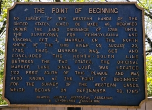
Somewhere beneath the Ohio River, on what was the river's north bank in 1786, Thomas Hutchens established what's now called the Point of Beginning, after which most lands to the west have since been mapped.
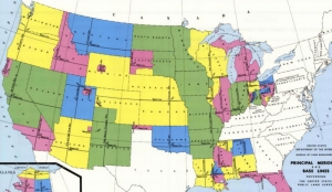
The Township-and-Range System, or Rectangular Survey System, commenced west of a stake that marked the northern extent of the boundary between Pennsylvania and Virginia, now West Virginia.
The system was created by the Land Ordinance of 1785 to survey the land ceded to the U.S. by the Treaty of Paris after the end of the American Revolution, and it's been used since as the primary method for recording claims to land.
Real property to the east, and in the Appalachian Mountain region, is still most often described in "metes-and-bounds" defined by landmarks and land features such as rocks, trees, streams, and ridges.
The new system, however, laid off nearly square sections that were further subdivided into smaller nearly square units. It established the pattern of development of the new nation west of the Appalachians, across which states are often more rectangular.
Few West Virginians seem to know about the point, seemingly because it's located on the state line, and since the state boundary follows the opposite shore of the Ohio River, the marker is for all intents and purposes located in Ohio, just across the river at the eastern end of East Liverpool, Ohio.
Hutchens and his team braved Indian attacks to survey the first seven ranges, which included all or parts of 10 present-day counties in eastern Ohio.
As the exact Point of Beginning is now underwater, the Ohio River having been locked and dammed for navigation, a monument commemorating the site has been raised along Ohio Route 39 some 1,200 feet north of the point, which was declared a National Historic Landmark in 1965.
The commemorative marker monument may be reached from the tip of West Virginia's northern panhandle from Chester, West Virginia, by following U.S. 30 north into East Liverpool then following Ohio Route 39 three miles west. There, visitors will find a collection of markers and exhibits.
Read also: Storied West Virginia monument stands forgotten in woods
Sign up to receive a FREE copy of West Virginia Explorer Magazine in your email weekly. Sign me up!


