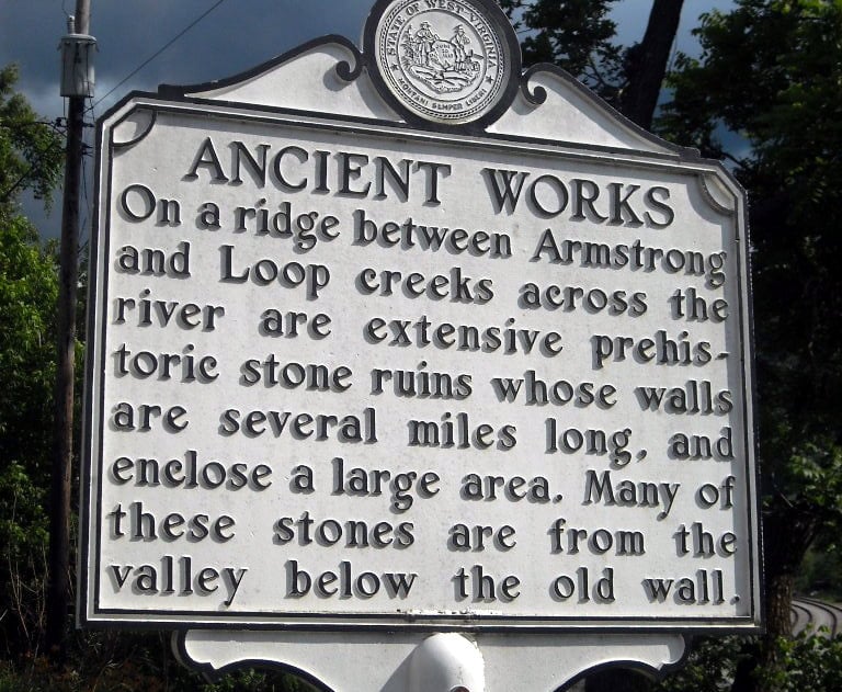
A series of stone walls, or wind-rows, of aboriginal construction on Armstrong Mountain, in Fayette County, have attracted the interest of scholars and antiquarians since European settlement.
The purpose of their construction is unknown. By default, archaeologists have concluded they may be of “ritualistic or ceremonial significance.” The walls are located on a parcel possessed by Western Pocahontas Properties.
Read also: Ancient Stone Walls, more than an old timer’s tale
Editor’s Note: This following article was first published in the journal of the West Virginia Archaeological Society, vol. 13., and was published on the World Wide Web through the Martin Collection.
The Mount Carbon Stone Walls: Description and History
By Joseph W. Inghram, Sigfus Olafson and Edward V. McMichael
ABSTRACT: Six windrows of stone of aboriginal construction are described which are found atop Mount Carbon, overlooking the Kanawha River in Fayette County, West Virginia. Other features of the site 46-Fa-l, are flint quarries in outcrops of Kanawha Black Flint, possible stone cairns, and flint workshop areas. The known history of the site is related, composed principally of much interest and speculation in the latter part of the 19th Century when many writers wrote much on the basis of little field work, and then a recent revival of interest by members of the West Virginia Archaeological Society. An annotated bibliography of principal references to the site is appended. Artifacts thus far recovered are non-definitive as to constructors, and function is considered ceremonial for lack of any other logical explanation.
The Mount Carbon Stone Walls are situated high on a mountain overlooking the Kanawha Valley in Fayette County, West Virginia. They have intrigued the imaginations of many since their discovery. The site, between Loop and Armstrong Creeks, has provoked many and varied comments by archaeologists, historians, and other interested persons.
The present issue of the West Virginia Archaeologist is being devoted exclusively to these stone walls, in order to clear the air of many misconceptions regarding them and to present what is actually known about the walls. For those looking for pat answers, no satisfaction will be forthcoming, since on the basis of present knowledge of the site, little definitive can be said of the walls.
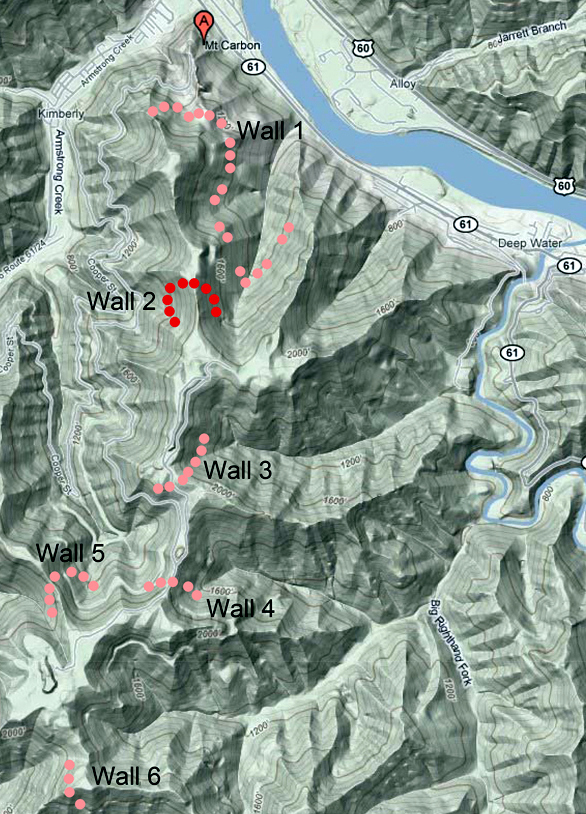
The site will be described by two workers who spent considerable time examining the site, Sigfus Olafson and Joseph W. Inghram, and their map of part of the site reproduced (Map l); contrary to some of the earlier accounts which depended upon hearsay evidence only, this account is the result of laborious, time-consuming effort on the mountain top, examining the site on the spot. Also included is a historical review of interest in the site, summarizing the extant works about the stone walls, with an appended annotated bibliography of articles about the site.
In an effort to learn more of the wall’s nature and builders, Dr. James ‘d. Kellar, now of Indiana University, spent most of one summer excavating in various areas of the site. The results are here published of a very discouraging season’s work, since little in way of artifacts or any definite information about the site was discovered.
For its historical value, and as the best of the earlier accounts of the walls, J. P. Hale’s SOME LOCAL ARCHAEOLOGY is reproduced in facsimile. In the later section of this article, Hale presents the sanest, most empirical account of the walls from an earlier date, and provides comparison with the walls’ present state. Also included in this article is an account of the opening of a mound, and this is included to make all of the contents of SOME LOCAL ARCHAEOLOGY more readily available, since copies of this pamphlet are scarce.
In the preparation of this issue of the West Virginia Archaeologist, the editor has done considerable collating of the Olafson and Inghram accounts of the walls, which were submitted as separate manuscripts, and occasional expansions have been made by the editor where deemed necessary. Hence, the present paper is attributed to all three writers. However, the site description is largely taken from Olafson; the site history more so from Inghram, while introductory and summary remarks are by the editor.
Here then is what is presently known of the Mount Carbon Stone Walls.
Site Description
The Mount Carbon Stone Wall site, designated 46-Fa-l in the West Virginia tri-nomial numbering system, is situated on and near the top of the mountain between Loop and Armstrong Creeks, on the southwest side of the Kanawha River, in Fayette County, West Virginia. The mountain has variously been called Mount Carbon, after the village at the foot of the mountain, or Loop or Armstrong Mountain, after the streams bounding the site to east and west The topography of the region is quite rugged. The elevation of the Kanawha River opposite this site is about 625 feet above sea level. The valleys of the tributary streams are in general narrow and V-shaped, and the mountains rise steeply from them to elevations of as much as 2325 feet above sea level, or 1700 feet above the river.
Geologically, all of the rocks above drainage are of Pennsylvanian age, with the top 200 feet belonging to the Allegheny Series and the remainder being Kanawha Series, and are composed of heavy beds of shale, sandstone, several coal seams and an occasional bed of thin impure limestone. An unusual feature is the presence of the Kanawha black flint, a highly siliceous rock used by Indians for the manufacture of various artifacts.
The ridge on which this site lies was originally covered with heavy forest growth, and though the largest timber was cut many years ago the site area itself has much timber on it now, and is thickly covered with underbrush. No land on this ridge has ever been cleared as it is much too rough for agriculture and no white people ever lived on it. Since this area was settled its population has been concentrated along the valley floor. Coal mining in this ridge began soon after the building of the first railway along the Kanawha River in 1873 and has continued until recent years. While some coal may remain it is now regarded as a worked out area. Sump areas are visible on the mountain top, a result of collapse of old coal mines.
The northernmost limit of the site is about one mile south of the mouth of Armstrong Creek, and from this point it extends southward for an airline distance of about three miles, or five miles if the meanders of the ridge top are followed. The principal feature of the site, is, of course, the “stone walls”. Actually windrows would be more appropriate in that these are not laid-up walls but rather crude rows of loosely piled rock. Beginning on the north, the first encountered (See Map 2). has been designated Wall 1. This is a U-shaped windrow of loosely piled rocks crossing the ridge as it slopes down to the Kanawha, just east of the mouth of Armstrong Creek. It is about one-half mile south of the river, but lies 1200 feet above river level or 1790 feet above sea level. This structure rests on a fairly level bench or shelf where it crosses the ridge, and is well preserved. It is about two feet high and about 20 feet wide.
As these windrows turn southward they soon reach steep slopes, as the ridge rises in that direction, and are lost in the rubble and loose soil. Local report would have the wall continuing, but close examination failed to confirm this. Inghram felt he could at isolated spots see remnants of the “walls” indicated by a dashed line on the map, but the steep slopes are of such a nature that they would not have supported any such structure very long.
The Kanawha black flint layer is exposed immediately above Wall 1, and a barometric elevation of 1920 feet above sea level or 130 higher than Wall 1 was noted. The ledge here is about 12 feet thick, and the ground between it and the wall is covered with flint debris and chips, among which were found several granitic hammer-stones.
Moving southward from this flint exposure, the ridge rises to a flat knob which was literally sprinkled with flint chips, then the ridge descends slightly to a point where the flint ledge was again noted, but showed little evidence of quarrying. From this gap, the ridge rises to the southward and the flint layer is again intersected, with much flint rubble in evidence, among which were found a few broken hammer-stones. About 4000 feet to the south of Wall 1, a second structure is encountered, termed Wall 2. (See Maps 1 and 2) It is slightly higher and somewhat narrower than Wall 1. It crosses the ridge where it is quite narrow, and runs down steep slopes on each side for about a hundred feet, then turns southward on the ridge flank, and is soon lost. Like Wall 1, it is also U-shaped. While the stones in Wall 1 are mostly of the size that one person could conveniently carry, many of those in Wall 2 would have required several to transport. The elevation of Wall 2 was 2200 feet above sea level.
From Wall 2 to the next Wall, number 3, a chain and compass map was made (Map 1), with the airline distance between the two walls being 3125 feet. Wall 3, like the others, is U-shaped, but its arms turn northward, as if to meet those of Wall 2. On the westerly or Armstrong Creek side of the ridge, it runs for about 400 feet before disappearing on the slopes. On the opposite easterly side, it runs about the same distance, and ends at a small hollow, which apparently had undermined any structure once present. A few additional segments of this wall were noted but there is so much rock in the area that its presence is uncertain. Wall 3, where it crosses the ridge, has many blocks of flint in it, all of which must have been carried uphill since the flint horizon at this point is 200 feet below Wall 3 is by far the heaviest of these structures, being about five feet high and 30 feet wide at the base where it crosses the ridge and maintaining these dimensions for some distance on either side of the ridge. The writers feel that the builders intended the Wall 2 and 3 segments to meet; but whether it was simply never completed, or the union was eroded away on the steep slopes is a moot point.
Southward from Wall 3, the ridge descends slightly and turns eastward for about one-quarter of a mile, then south into a gap. From this it rises to the south, and at a distance of about one mile by the ridge meanders, or 3600 feet airline from Wall 3 is Wall 4 (See Map 2).). It is a small V-shaped formation, with one arm pointing south and the other west. This wall is smaller and less conspicuous than any of the previous examples, and the spur crossing has been disrupted by an old logging trail.
On a spur between Stop Hollow and Little Stop Hollow, to the west of Wall 4 about 1500 feet distant, Wall 5 is found. Wall 4 lies at an elevation of 2200 feet above sea level, while Wall 5 is about 100 feet lower.
Finally, there is rumor of a sixth wall segment on a spur to the south of Wall 4, but detailed data on this structure are not available.
It is possible that there are additional features of this site farther south, but the mountain top has only been explored in detail five or six miles from the river. The ridge however, winds south for a considerable distance.
Associated Features:
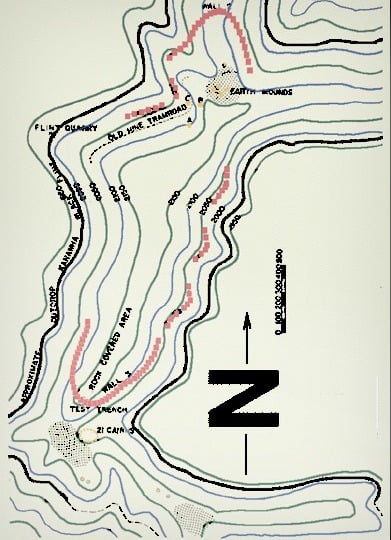
Also in the site area are a number of rock cairns, flint quarries and workshops. In the area between and near Walls 2 and 3, a number of cairns are found (See Map 1).). About 400 feet south of Wall 2 is a cairn which has been excavated. Farther south, near the end of an old mine tram-road, are a number of small oblong earth mounds which are probably the soil from uprooted trees that have rotted long ago, but in among them is a definite camp or workshop area. Though well above the flint horizon, the surface is littered with flint debris, and with very little digging projectile points, scrapers, etc., were found.
A little further south, as shown on the map, are three stone mounds, (A, B, C, Map 1) two of which have been entirely dismantled, but the third, a small turtle shaped affair seems to be intact (Excavated by Kellar, see paper that follows). Some of these mounds may have been excavated by Colonel P. N. Norris, for the Smithsonian Institution, who was on Mount Carbon in 1884 (See Thomas, 1894, p. 407). These cairns are in or near a cove formerly having a good spring, but coal mining beneath has fractured the strata in such a way as to disturb the drainage system and this spring now runs only after heavy rains.
A few hundred feet southeast of Wall 3, eleven small cairns have been excavated. There may be ten additional undisturbed ones also in the area. These amount to heaps of stone no more than six inches high, and about five feet in diameter. About three hundred feet farther south are two large pits where cairns have been dug. All this digging has the appearance of having been done many years ago. (One of these was excavated by Kellar, and is described in this issue.)
On top of the ridge at the head of Little Stop Hollow, about a quarter of a mile south of Wall 4, appears to be another habitation area as a great deal of flint debris is scattered over a flat area.
Another flint quarry area occurs on a spur immediately north of Stop Hollow. This is encountered when approaching the site up the Stop Hollow trail (indicated on Map 1). Depressions in the flint outcrop represent quarrying activities.
Artifacts Recovered:
In the writers’ reconnaissance of the site, few artifacts were recovered. While the inherent difficulty of surface hunting in a woodland area that has never been cultivated did not help the matter, the site has also frequently burned over, leaving the ground bare, so that local people visiting the site for the past 150 years may well have carried away most of the visible artifacts.
Hammer-stones, mostly broken, were the only plentiful artifact; otherwise in the habitation areas most flint objects were so crude as to be flint workers rejects. Others found include: some stemmed and side-notched projectile points, side scrapers, and crude choppers. They are, in general made of the poorer grades of the readily available local flint. Not a single pottery was noted or recovered, though Cyrus Thomas (1894) “fragments of coarse pottery” as being found in some of the hilltop stone mounds, but this does not specifically refer to the Mount Carbon examples.
McMichael has seen a little additional artifactual material from the mountain top, derived from the several workshop areas of the site. In the collection of Dr. John Rutherford, Montgomery, is a poll of a full-grooved axe of a dark igneous rock which came from the workshop area south of Wall 2; flint artifacts include 1 contracted stemmed projectile point, 1 side-notched drill, and a number of crude blank forms, one of which is circular in shape. All the flint was Kanawha black type.
Other Wall Sites in the Area:
Just above the mouth of Paint Creek, seven airline miles- northwest of the Mount Carbon site, there is another Wall site. This is a single wall crossing a ridge, and is about 800 feet long according to Norris (See Thomas, 1894, p. 411) who visited and mapped the site. Norris map was not included in the 12th Annual Report, so it is reproduced here, (Map 3) from Norris’ original manuscript (Bur. of Amer. Ethno. MS. No. 2400). Inghram has also seen this wall, and reports it is similar to the Mount Carbon examples.
A resident of Raleigh County, West Virginia, reports another stone wall on top of a high mountain, 16 miles south of Mount Carbon. A newspaper article notes other examples as occurring in Logan County, West Virginia, near Omar. Hale (1891, p. 47) mentions another wall as occurring on a natural terrace below Rush Creek, Kanawha County. Except for the Paint Creek instance, these amount to little more than rumor, having never been field checked.
Remarks:
Much comment has been made about the function of the “walls” in the earlier literature. Various theories have been advanced regarding the purposes for which these walls may have been built, such as that they were defensive works, fences to keep animals out of cornfields, game traps, or ceremonial enclosures.
The writers’ cannot regard these walls as defensive for several reasons. They are not- well situated for defense, generally being on steep slopes in- stead of on the brows of the ridges where they would have had to be placed to be effective. They are not high enough to afford much protection, unless used to hold upright a log stockade or other such superstructure, and there is no evidence that such was used. Furthermore, the very size of these enclosures, if that is what they were, rules out consideration of a stockade.
It also does not seem likely that these were enclosures into which game animals were driven, after the manner of some western tribes. The buffalo about the only animal that could have been so taken, seems to have been a late arrival in the area since no evidence of its presence is found in any except possibly very late sites. It was also an animal which disliked rugged terrain, and Mount Carbon is about the last place one would expect to find them. The idea that these were fences to keep animals out of fields hardly needs further comment.
This then, leaves the possibility that these structures may have had some ritualistic or ceremonial significance in the life of the people who built them. However, this is only supportable by virtue of the fact that other explanations are inadequate and are eliminated.
Site History:
The Mount Carbon Wall site has probably been known since the latter 1700’s when the Kanawha valley was first settled. However, the first definite comment of awareness of the walls would probably be in 1818, for Atkinson (1876) relates that Dr. Thomas S. Buster, who told Atkinson about the walls, had first seen them 58 years ago. Dr. Buster took title to several tracts of land in the area of the mouth of Armstrong Creek, and appears to be the first permanent settler in the immediate area of the walls, though Paddy Huddleston was living across the river at an earlier date. The senior Buster, however appears to have had little interest in the walls, having lived at a time when Indians were still a threat, not a curiosity. Most of the earlier information derives from his son, Dr. Thomas S. Buster, Jr.
The earliest published account appears in A HISTORY OF KANAWHA COUNTY (1876) by George W. Atkinson, who credits his information to both Dr. Buster and a William Morris. Atkinson’s account is rather fanciful, and reflects the fact that he never visited the site himself. He describes it as follows:
“The wall commences on the west side of the mountain, fronting on the river, and lying immediately above Armstrong Creek, about one hundred yards from the top of the mountain, and follows the meanderings of the river ridge, near its top, until it reaches the slope that extends down to Loup Creek, near the Big Falls. The entire length of the wall, from one extreme to the other, is perhaps three and a half miles. It is built of flag-stones, such as are usually seen upon the surface of the ground, laid in the walls without cement or mortar, after the style of modern stone fences.”
In the 1870s, a Captain William N. Page, a civil engineer representing coal interests of Washington, D. C., arrived in the area and became interested in the walls. Again the principal informant seems to have been Dr. Buster, Jr. but Page apparently did visit the site in 1877, though from his description his examination of the walls could not have been too intensive, since he assumes the walls are continuous, being “8 to 10 miles” in length. It seems most unlikely that Hale (1898) only 21 years later would find them not continuous, as they are today. Page described the walls thusly:
“The wall in question has been constructed along the approximate contour of this mountain, about 300 feet below the high summits and just under the low gaps, conforming as nearly as possible to such contour, it winds around each rib or spur, until a low place is found through which to pass, when it finally crosses the main ridge and returning in the same manner on the other slope, makes a complete enclosure facing the river, of about three miles in length and varying in width from a hundred yards to a mile or more (Hale, 1891, p. 39).”
Page’s account is first published in Hale’s HISTORY OF THE GREAT KANAWHA VALLEY (1891, pp. 40-46), and is subsequently reproduced in several local histories with some editing and often some distortion. Two such sources are Peters and Carden (1926) and, in paraphrase, Hale again uses the Page account in HISTORY AND MYSTERY OF THE KANAWHA VALLEY (1897). A little later than Page, in the period between 1883 and 1885, Colonel P. W. Norris visited the site, working under Cyrus Thomas, Smithsonian Institution, in connection with a survey of mounds in Eastern United States. In the 12th ANNUAL REPORT, BUREAU OF ETHNOLOGY (Thomas, pp. 409, 410, 1894) a brief comment appears about the walls:
“About 1000 feet above the town of Mount Carbon are heavy and valuable veins of coal. Some hundreds of feet above these are the remains of an ancient stone wall, the tortuous course of which can be followed along the steep face of the mountain fully a mile, then across its sharp summit and a like distance upon the other slope. It is said that it can be traced fully as much farther in such a manner as to connect the ends, and thus inclose a large area of the higher portion of the mountain. Little of this wall is now in place, it rarely being more than 1 or 2 feet in height, but the line of flat rock strewn over a space of many feet in width, and often far down the mountain slope, indicates material largely in excess of that in an ordinary stonewall fence.”
From this comment, Norris made no attempt to follow the walls in de- tail, but relied upon local informants as did his predecessors. He did however, excavate at least one cairn in the area of the site, and putatively suffered a heart attack while so engaged and died as a result in January 1885*, much to the detriment of archaeological knowledge of this area. In October, 1897, Dr. John P. Hale, then president and guiding light of the West Virginia Historical and Antiquarian Society, visited the walls and employed a surveyor to map them. A report on this was made the following year in a pamphlet entitled SOME LOCAL ARCHEOLOGY (1898, reproduced in facsimile in this issue). In this article, undoubtedly the best of the early accounts, he soundly describes what could then be found, and dismisses all the earlier speculations regarding the function of the walls. Ne alludes frequently to a map in the text, but in all copies of this pamphlet seen to date, no map is to be found.
In the ensuing years since 1900, interest in the site has lagged save for the occasional resurrection of Page’s description of the walls. Not until the formation of the West Virginia Archaeological Society did concern with the site revive. In the mid-1950s, Inghram and Olafson spent considerable time on the site, mapping it and locating the various features herein reported. Since then other Archaeological Society members have continued to visit the site and gather more information about the walls. Under this stimulus, Dr. James N. Kellar, then of the University of Georgia, was employed jointly by the University of Georgia and the West Virginia Archaeological Society, to spend the 1958 summer on the site in order to learn what he could. The results of his work (contained in this issue) demonstrate the frustrating nature of this site in the attempt to learn of its function or builders.
Otherwise, there have been frequent newspaper, periodical and trade paper accounts of the walls, which generally only add to speculations of earlier years, and provide no new concrete facts about the site.
Annotated Bibliography of the Mount Carbon Stone Walls
Atkinson, George W.
1876. HISTORY OF KANAWHA COUNTY. Printed by West Virginia Journal, Charleston, 338 p.
“Ancient Walls on Loop Creek Mountain”, pp. 93-95. Gives a brief description of the Mount Carbon structures, but has little value in that the author depends on local reports and rumors (esp. from Dr. Thomas S. Buster and William Morris), and never visited the site himself. He concludes it was a game trap. This is apparently the earliest published reference to the walls.
“Gus of Gisholtz”
No Date: “Mound Builders and the Mount Carbon Walls” in FINE POINTS AND LOOSE ENDS, Vol. 2, No. 4 (a machine tool trade paper). 3 p., 2 maps, 7 plates. Wisconsin. Relates a visit to the site with some descriptive detail, and much speculation as to function and the builders of the walls. The map of the walls presented is derived from West Virginia Archaeological Society members work, and is accurate. He also admits to having “reconstructed” a section of wall 3,as “it might have been,” and this remains “reconstructed” to this date.
Hale, John P.
1886. TRANS-ALLEGHENY PIONEERS. The Graphic Press, Cincinnati. 330 p.
p. 70, a brief comment on Mount Carbon walls, probably derived from Atkinson’s account.
1891. HISTORY OF THE GREAT KANAWHA VALLEY.
2 vols. Brant, Fuller and Co., Madison, Wisconsin. 308 p. and 307 p.
p. 40-46.”Prehistoric Masonry” by Capt. W. N. Page, C. E., presents the original publication of Page’s account of the walls, and the entire first chapter is devoted to Indians and prehistoric remains (p. 48). Page apparently did visit the wall site in 1877, but from his description he could not have spent much time investigating the site, but rather depends on local informants, esp. Dr. Buster, Jr., for his information. Also described is the finding of Late Prehistoric skeletons in a railroad cut in the village of Mount Carbon.
1897. HISTORY AND MYSTERY OF THE KANAWHA VALLEY.
A paper read before the West Virginia Historical and Antiquarian Society, Jan. 19 1897. Butler Publishing Co., Charleston. While largely devoted to the discovery of a curious wooden statue in a sandstone crevice some 12 miles above Charleston (this can still be seen in the State Capitol Museum, Charleston), on pp. 10-12, Hale reviews the Page account of 1891, and speculates considerably about the walls- much in contrast to his 1898 work.
1898. SOME LOCAL ARCHAEOLOGY.
A paper read before the West Virginia Historical and Antiquarian Society, Jan. 18, 1898. Gazette Publishing Co., Charleston, 14 p., 1 fig., p. 1-6.”Opening Mound on Twenty-Mile Creek”, relates the excavation of a mound. Pp. 7-14. “Examination of Ancient Stone Works on Mountains East of Paint Creek” presents, save for the mislocation on Paint Creek,the soundest early description of the Mount Carbon Stone Walls. Apparently a map was drawn up by a surveyor, but in no copies seen is such a map present. Site features are empirically described, and earlier speculation on function debunked.
Peters, J. T. and H. B. Carden
1926. HISTORY OF FAYETTE COUNTY. Jarrett Printing Co. Charleston, 772 p. Chapter 2, on “Prehistoric Inhabitants of Fayette”, pp. 11-25, with pp. 13-25 devoted to another reprinting of Page’s account of the walls. They also reprint, without credit, much from Hale’s HISTORY OF THE GREAT KANAWHA VALLEY, regarding prehistoric remains .
Suter, John F.
1953. “A Mystery of the Mountains” in CARBIDE NEWS, May 1953 (trade paper). Z pp., 7 plates. A brief account of a visit to the wall site by Suter and Walter, relating an attempt to map the site (no map is reproduced however).
Thomas, Cyrus.
1894. “Report of Mound Explorations” in 12th ANNUAL REPORT, BUREAU OF AMERICAN ETHNOLOGY, 1890-91. Government Printing Office, Washington, D. C. 730 p., Pp. 409-410. Brief comment derived from Col. P. Norris on the wall site. While Norris visited the site, he did little extensive investigation and appears to have also relied greatly on local reports. P. 411, a comment on the Paint Creek stone wall.