


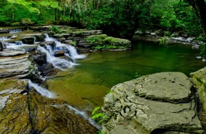
Camp Creek State Forest, in southern West Virginia, protects 5,269 acres of mountainous woodland drained by Camp Creek, a tributary of the Bluestone River near Princeton. Its terrain descends rapidly from summits southwest of Flat Top Mountain, at 3,000 feet above sea level, to narrow bottoms along Camp Creek and its Mash Fork, at 2,000 feet above sea level.
Much of the original forest was cleared for small farms in the late 1800s or had been logged by the Blue Jay Lumber Company in the 1930s. The West Virginia Conservation Commission began purchasing tracts for the forest in 1945, and opened the area to the public in 1953. Many trails and old farm roads wander the forest and provide access to former pastures and ridge-top clearings. The forest supports excellent deer, turkey, and small game hunting. Camp Creek is well-known trout stream. The stream is stocked in spring, and its headwaters are intermittently stocked with trout fingerlings. In 1988, the West Virginia Legislature transferred 487 acres of the original forest to the state park system as Camp Creek State Park.
Location
Camp Creek State Forest is located south of Ghent, West Virginia, and north of Princeton, West Virginia, in Mercer County, in the Bluestone Region of southern West Virginia.
Camp Creek State Forest
2390 Camp Creek Road
Camp Creek WV 25820
CCSF Website
Phone: 304-425-9481
Hotels near Camp Creek State Forest
Ghent (WV) Hotels
Princeton (WV) Hotels


