


SINKS GROVE, W.Va. — Unknown to many residents of the Greenbrier Valley in southern West Virginia, a six-mile crack in the surface of the earth has been hiding beneath their feet.
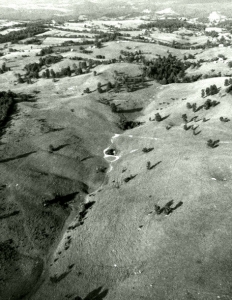
Visible only from the air, the "Monitor Lineament" is one of the strangest landforms in this scenic landscape of bluegrass pastures, vanishing brooks, and healing springs.
Coursing in a straight line across northern Monroe County from near Sinks Grove to Second Creek, the lineament is seemingly impossible to perceive at eye-level.
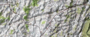
A thoughtful observer might recognize it as an exceptionally regular row of sink-holes, each marking the location of a cavern beneath — all part of a maze of caverns that underlies the "levels" of the southern Greenbrier Valley.
Though the average valley resident may not know of the lineament, most cavers and geologists do. Only a handful of obscure sources speak of it online, though a cursory inquiry on social media inspired many contributing voices.
What is the lineament and how did it form? Simply put, the lineament is a minor fold, or wrinkle, in the topmost layers of the Earth's crust. It was named by geologists for the community of Monitor, along which a line of sinkholes runs.
Cavers and geologists agree that the slow movement and warping of the crust over millions of years created this fold and others nearby, though the Monitor line does not match the general trend of most other folds in the Appalachian Mountains.
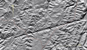
Geologist Nick Schaer speculates that the lineament may be a recent development, geologically speaking. He notes that the fold extends beyond the valley's "karst" — the porous layer of limestone in which the region's caverns have developed.
"You can see that the formation expresses itself some distance beyond the karst region," Schaer said. "Of course, the lineament is most obvious in the karst, where sinkholes are well-developed, but, particularly to the west, you can see that it extends beyond the karst."
As the line extends beyond the limestone layer, it might infer that the fold occurred after the formation of the bed of limestone, though Schaer said he was unaware of any studies that looked at the larger geologic structure of the region.
Caver Justin Beverage, a recent graduate of the environmental geoscience program at Concord University, speculates that the line is an extension fault associated with larger folds nearby.
"It's likely that the strain of the fold event caused the rocks to fracture — like bending Play-Doh into a fold and looking near the apex of the fold," Beverage said.
"Looking at a topographic map, it appears there is another lineament two-miles north-trending the same way. This would reinforce my guess since extension faults in fold-systems usually happen in groups."
According to Bill Balfour, who lectures on the region's karst, hydrologists and geologists employed by the U.S. Geological Survey are re-mapping Monroe County for the first time in decades, and many local cavers hope the new survey will tell them far more about the karst.
Read also: Prehistoric mystery underlies Dunloup valley; Ghost town may soon be accessible to hikers

Interested in exploring caverns in the Greenbrier Valley? Lost World Caverns, a public show-cave in the Greenbrier levels at Lewisburg may be a good place to start.
Visitors at Lost World are welcome to explore an above-ground museum or descend beneath the floor of the valley into a lighted section of the caverns. Wild-cave expeditions are also led deep into the cavern's most remote recesses. Find out more: Caving in West Virginia
Rare, mysterious diamond found in 1928 in West Virginia
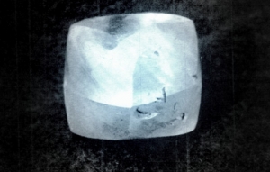
Diamonds don’t exist naturally in West Virginia, yet one of the largest ever found was discovered accidentally in a horseshoe pit in Monroe County in 1928. Geologists are still at a loss to explain how it got here, though speculation has never died down. The Punch Jones Diamond remains the largest alluvial diamond ever discovered in North America and the third largest found on the continent overall. Read the full story here.
Sign up to receive a FREE copy of West Virginia Explorer Magazine in your email weekly. Sign me up!


Facebook Comments