


FAYETTEVILLE, W.Va. — Nearly all who cross the towering New River Gorge Bridge in West Virginia are affected by the journey. Soaring 876 feet above the New River, its span affords motorists a grand vista of one of the most remarkable landscapes in the Appalachian Mountains.
But only a few of the millions of tourists who now visit the New River Gorge National Park and Preserve have discovered the winding scenic parkway that leads through the gorge beneath the bridge.
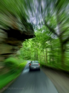
Beginning near the park's Canyon Rim Visitor Center and ending in Fayetteville, West Virginia, the 10-mile route allows motorists to explore the wonders of the gorge without leaving their vehicles—though pull-offs with interpretive waysides are frequent along the way.
"The drive is one of the best ways to learn about the gorge and see the bridge in all its glory," says park ranger Jodi French-Burr.
"We have a brochure guide for the route that we can provide here at the visitor center, after which park visitors can enjoy a drive through the gorge at their own pace."
The journey may be managed in as little as 20 minutes, though travelers may wish to allow an hour or more to tour the park visitor center and boardwalk and explore wayside exhibits and overlooks.
"One thing we do stress is that this is a winding road—with hairpin turns and a railroad crossing—and large trucks and RV campers should not attempt it," French-Burr said.
The route is not suitable for large vehicles, RVs, or trailers. Due to steep dropoffs and tight switchbacks, it should also be avoided during winter weather.
Though narrow and winding, the through-the-gorge route was among the chief ways to traverse the canyon before the New River Gorge Bridge was completed in 1977. The road accommodated two-way traffic, though most of it is now one-way.
Along the way, visitors will be able to visit overlooks, waterfalls, and hiking trails and have the opportunity to encounter rock climbers and whitewater paddlers along the way.
Here are some of the highlights motorists will encounter on the route.
1. Canyon Rim Visitor Center
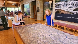
Any tour of the region around the New River Gorge Bridge might best begin with the park's Canyon Rim Visitor Center, which includes exhibits, observation areas, an information desk, a park shop, and public restrooms. Visitors are also welcome to climb a network of stairs to an up-close bridge overlook. A wheelchair-accessible overlook is also available off the visitor center parking lot near the bridge.
2. Beneath-the-Bridge Overlooks
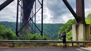
Four parking areas are located along the parkway, Fayette Station Road (CR-82), beneath the bridge's northern end, allowing motorists to observe the bridge structure from below. Wayside exhibits interpret the history of the bridge and the surrounding gorge. Feel free to get out of the car and stretch your legs. This is also a favorite vantage point for photographers. The laughter you may hear overhead is often that of tourists exploring the catwalk beneath the bridge.
3. Fayette Station Bridge
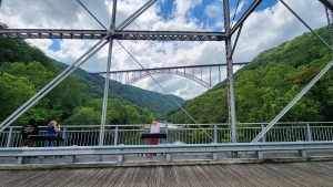
Near river level, the parkway runs directly through remnants of the townsites of Fayette and South Fayette, much of which is obscured by foliage throughout summer and autumn. The reconstructed Fayette Station Bridge, which reopened in 1998 as the Tunney Hunsaker Bridge, spans the river and includes pedestrian walkways that provide fantastic views of the river below and the New River Gorge Bridge above.
4. Fayette Station Rapids
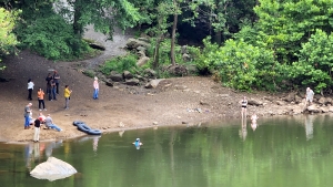
The park service has established parking and boating access areas just past the Fayette Station Bridge. Many whitewater boaters use this access to take out from the lower New River run, and traffic can become congested. However, the site also provides motorists an opportunity to see the river up close. The Fayette Station Rapids, the last cataract on the New River upstream of Hawks Nest, is here. Paddlers can be seen navigating the rapids.
5. Wolf Creek Falls
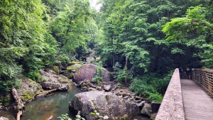
A small tributary of the New River, Wolf Creek tumbles through boulders and waterfalls in its steep descent from Fayetteville. The scenic stream can be observed from the car, though motorists may opt to park in pull-offs along the road and walk out onto a footbridge that spans the creek. The park's Kaymoor Trail and Bridge Trail also lead off from the parking area, providing visitors an opportunity to walk a short way on either trail or fully engage in a strenuous hike.
6. Historic Fayetteville

The parkway ends at the US-19 expressway in Fayetteville at Keller's Corner. Motorists are welcome to cross the expressway, stop in at the Keller's Corner Gift Shop, and enter the town's historic district by way of Keller Avenue. They may also turn right and enter the district on North Court Street or turn left and return to the Canyon Rim Visitor Center. The historic district is filled with shops and restaurants that will appeal to travelers and outdoor enthusiasts. More information may be found at the Fayetteville Visitor Center.
Parkway gift shop on US-19 at Fayetteville for sale
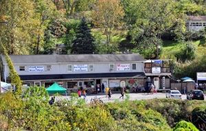
Among the New River Gorge region’s most visible commercial locations, this 1.3-acre property on the US-19 expressway is the nearest available commercial property to the southern end of the New River Gorge Bridge, the centerpiece of America’s newest national park. More than 30,000 motor vehicles pass daily, including travelers and a growing number of tourists, notably passengers in tour buses traveling the scenic parkway through the gorge. FIND OUT MORE HERE!
Parkway Route Directions
Leaving the parking lot of Canyon Rim Visitor Center, return back to the US-19 expressway. Turn right (north) onto US-19, then take the next right onto Lansing-Edmond Road (CR-5 and CR-82). At a quarter mile, turn right onto "Fayette Station Road." The road forks almost immediately; follow the lefthand fork.
Fayette Station Road continues into the gorge, passing under the New River Gorge Bridge twice in its descent to the river and passing exhibits along the way. At the bottom, the road crosses the reconstructed Fayette Station Bridge. Motorists may opt to park just beyond the bridge in the Fayette Station parking area. Google coordinates to the parking area are 38.065581, -81.080096. After leaving Fayette Station, the road winds up to Fayetteville. The entire trip from the visitor center to Fayetteville takes about 40 minutes (without stopping).
Download a Fayette Station Road Audio Tour
This CD will carry travelers back in time along Fayette Station Road to when coal mining was the largest industry in the region, and more than 40 coal mining towns lined New River Gorge. The road tour is eight miles long and takes about 45 minutes to complete. Download an audio tour of the route.

Sign up to receive a FREE copy of West Virginia Explorer Magazine in your email weekly. Sign me up!


Facebook Comments