The Big Sandy River drains roughly 4,140 square miles of the rugged Cumberland Mountains region of Kentucky, Virginia, and West Virginia. Nearly 23 percent of its drainage, or 940 square miles, is located in a narrow strip along the southwestern West Virginia border, an area approximately 115 miles long and eight miles wide. The river forms the boundary line between Kentucky and West Virginia.

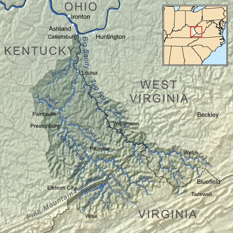
The Big Sandy is formed by the union of its Tug and Levisa forks, which join at Fort Gay, West Virginia. From this point, the river flows northward to empty into the Ohio River at Kenova, West Virginia. Its Tug Fork begins on the western slopes of Flat Top Mountain near the Virginia border with West Virginia.
Tug Fork flows in a northwesterly direction to its mount at Louisa. For a short distance below the boundary line of McDowell County, the fork forms the boundary line between Virginia and West Virginia; for the remainder of its length, Tug Fork forms the boundary between Kentucky and West Virginia. Levisa Fork flows northwesterly from its sources to Paintsville, Kentucky, turning northeasterly and joining the Tug Fork at Louisa. The Big Sandy and Tug also form the western border of the Hatfield & McCoy Region.
History
The formation of roads came slowly in the thick-forested areas surrounding the Big Sandy River. From the 1830s until the Norfolk & Western Railroad was built in the 1880s, steamboats traveled the entire length of the Big Sandy, providing exchange of produce, travel for passengers, and mail delivery in isolated areas. Poled wooden flats called “push boats” were executed when the river’s water was too low.
The Big Sandy was the site for multiple battles during the Civil War, the most famous being the Battle of Middle Creek in Eastern Kentucky and John’s Creek. The Hatfield-McCoy feud, which took place along Tug Fork in the 1880s, was one of the valley’s most cited events.
The Norfolk & Western Railroad was built along the Big Sandy during the late 1880s. The formation of the railroad resulted in the mining of the area’s deposits of coal, which became the primary industry of the Big Sandy watershed and remains so today.
Two popular folk tunes take their name from the Big Sandy River — “Sandy River Belle” and “Big Sandy River.” Loretta Lynn’s “Van Lear Rose” and Dwight Yoakam’s “Bury Me” also mention the Big Sandy.
Name Origin
Some sources claim the Big Sandy River was called the “Chat-ter-a-wha,” by a unidentified Native American tribe, meaning “the river of sandbars.”
Variant Names
Big Sandy Creek, Chatarrawa, Chattararawha, Chattaroi, Great Tattaroy River, Sandy Creek, Si-ke-a-ce-pe, Tateroy, Tatterio, To-ter-a, To-ter-as, To-ter-oy, Totteroi, Totteroy Creek, We-pe-pe-co-ne, We-pe-po-co-ne-ce-pe-we