The coal-producing areas of West Virginia have been traditionally defined as fields, each field corresponding to a given geographical location or region of the state.
Our readers should note that a coalfield is a geographical label, not necessarily related to geological terms used to describe coal, such as seam, coalbed, or series. For example, there are several Pocahontas coal seams found in West Virginia—Pocahontas No. 6, Pocahontas No. 4 and Pocahontas No. 3—which can be found in areas outside the Pocahontas Coal Field.
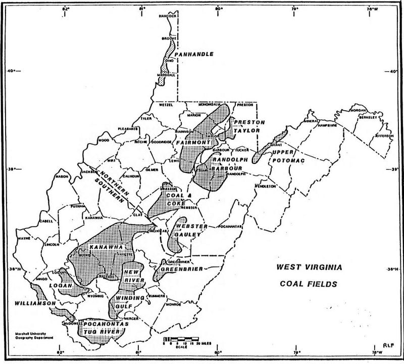
The coal-producing regions of the entire state often were, and still are, referred to as the West Virginia Coal Fields. In addition, the coal-producing lands lying south of the Kanawha River and New River were referred to as the Southern West Virginia Coal Fields, since at least the early 1900s. See, for example, this early advertisement marketing coal from the mines of southern West Virginia. The map at right illustrates how the fields were divided into northern and southern fields.
There are varied opinions on the number of coalfields in West Virginia, but for our purposes, we will define only eleven coal fields, which matches the method of dividing the coalfields in use since at least the early 1900s which is illustrated in the map of the West Virginia Coal Fields shown at right.
Southern Division
The Southern Divison has 52 seams of coal of sufficient thickness to be minable. The Southern coals lie in the Pottsville Series, which is in turn subdivided into the Kanawha, New River, and Pocahontas Groups. Some of the more productive seams included the Sewell, Fire Creek, Beckley, Pocahontas No.3, Pocahontas No.4, Kanawha No. 2 Gas, Eagle, Coalburg, and Kanawha No. 5 (Splint).
Coal Fields in the Southern Division
1. Pocahontas Coal Field includes the counties of Mercer (part) and McDowell (part).
2. Tug River Coal Field includes the counties of McDowell (part) and Wyoming (part).
3. Williamson Coal Field includes the counties of McDowell (part); Mingo; and Wayne (part).

4. Logan Coal Field includes the counties of Logan (part) and Wyoming (part).
5. Winding Gulf Coal Field includes the counties of Wyoming (part) and Raleigh (part).
6. New River Coal Field includes the counties of Raleigh (part) and Fayette (part).
7. Kanawha Coal Field includes the counties of Kanawha; Boone; Logan (part); Lincoln (part); Putnam (part); Clay (part); Nicholas (part); Fayette (part); and Raleigh (part).
8. Greenbrier Coal Field includes the counties of Greenbrier (part); Summers (part); Raleigh (part); and Fayette (part).
Northern Division
Fourteen coal seams are found in the Northern Division but the best known and largest producer has been Pittsburg seam. The Lower Kittaning, Upper Kittanning, Upper Freeport, Sewickley, and Washington seams have also been mined but in lesser amounts.
Coal Fields in the Northern Division
9. Elkins Coal Field includes the counties of Braxton (part); Webster (part); Lewis (part); Upshur (part); Randolph (part); Tucker (part); Grant (part); and Mineral (part).
10. Northern Panhandle Coal Field includes the counties of Hancock (part); Brooke; Ohio; and Marshall (part).
11. Fairmont Coal Field includes the counties of Monongalia; Marion (part); Harrison (part); Taylor; and Preston.