
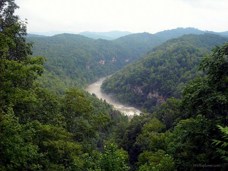
The Gauley River begins high in the Allegheny Mountains of West Virginia and travels approximately 107 miles before joining the New River at Gauley Bridge to form the Kanawha River.
Along the way, it changes dramatically. In its upper reaches, it drains a mountainous landscape of forests and tributary streams. Farther west, it enters Summersville Lake, the state’s largest lake, before emerging below Summersville Dam and plunging through the steep gorge that has made the lower river famous for whitewater.
The Gauley is therefore more than a rafting river. It is one of the principal waterways of central West Virginia, linking some of the highest mountains in the state with the Kanawha Valley and ultimately the Ohio River.
Where does the Gauley River begin?
The Gauley River rises in the mountains of Pocahontas County in eastern West Virginia at an elevation of about 4,600 feet.
From its headwaters, the river flows generally west-southwest across the Allegheny Plateau. Mountain streams feed the Gauley as it travels through a sparsely populated landscape toward Webster and Nicholas counties.
Important tributaries include the Williams, Cranberry, Cherry, and Meadow rivers. Together with numerous smaller streams, they drain a watershed of more than 1,400 square miles.
The upper Gauley differs considerably from the river most visitors encounter during the famous fall whitewater season. Here, the river is part of a broader mountain drainage system carrying water westward from some of the highest terrain in West Virginia.
The Gauley River and Summersville Lake
One of the river’s biggest changes occurs near Summersville, where Summersville Dam impounds the Gauley to form Summersville Lake.

The lake has become a major recreation destination in its own right, attracting visitors for boating, fishing, swimming, and other outdoor activities. Below the dam, however, the Gauley changes character again.
Water released through Summersville Dam enters a steep, rocky gorge. Scheduled releases in the fall create the high-volume flows associated with Gauley Season, when rafters and kayakers arrive to run some of the most difficult whitewater in the eastern United States.
The dam therefore creates an unusual contrast. Above it lies a broad mountain lake; below it begins a narrow river gorge internationally associated with whitewater recreation.
Gauley River National Recreation Area
The lower Gauley’s rugged landscape is protected in part by Gauley River National Recreation Area, established in 1988.
The National Park Service protects approximately 25 miles of the Gauley River and six miles of the Meadow River within the recreation area. The protected section passes through steep, largely undeveloped gorges and valleys.
Over those 25 miles, the Gauley drops more than 668 feet and encounters more than 100 rapids. In places, the river has cut a gorge approximately 500 feet deep.
Road access is limited along much of this stretch, helping preserve the river’s isolated character. Forested slopes, cliffs and enormous sandstone boulders dominate many views from the water.
Gauley River National Recreation Area is administered alongside nearby New River Gorge National Park and Preserve and Bluestone National Scenic River.
Whitewater rafting on the Gauley River
Whitewater rafting is the activity most closely associated with the lower Gauley, particularly during Gauley Season in September and October.
Scheduled releases from Summersville Dam send large volumes of water through the gorge, where the river’s steep gradient, constrictions, and sandstone boulders create powerful rapids. The Upper Gauley contains rapids rated as high as Class V+, while the Lower Gauley includes Class III through V whitewater.
Among the Upper Gauley’s most famous rapids are Insignificant, Pillow Rock, Lost Paddle, Iron Ring and Sweet’s Falls, collectively known as the Big Five.
Commercial outfitters operate guided trips during the rafting season, while experienced private boaters also travel to West Virginia for the fall releases.
Read more: Gauley River whitewater rafting and Gauley Season
Where does the Gauley River end?
After leaving the whitewater gorge, the Gauley continues toward the community of Gauley Bridge in Fayette County.

There it meets the New River in one of West Virginia’s most important river confluences. Neither river continues under its former name. Instead, their combined waters become the Kanawha River, which flows northwest through Charleston and eventually enters the Ohio River at Point Pleasant.
The confluence means that water beginning high in the mountains of Pocahontas County ultimately becomes part of a much larger river system draining toward the Mississippi River and the Gulf of Mexico.
The town of Gauley Bridge takes its name from an early bridge that carried the James River and Kanawha Turnpike across the Gauley near the confluence.
Why is it called the Gauley River?
The origin of the name Gauley is uncertain.
Over the years, several explanations have been proposed for the unusual name. Older accounts sometimes presented particular theories as established fact, but surviving historical evidence does not appear to resolve the question so neatly.
That uncertainty matters because many American river names can be traced with greater confidence to Indigenous languages, European settlers, distant places, or obvious landscape features.
The Gauley’s name instead presents a historical puzzle, with competing explanations reaching back to early European exploration and settlement in the Appalachian Mountains.
Communities along the Gauley River
Because much of the Gauley passes through mountainous and deeply dissected terrain, large cities never developed along its banks.
Communities associated with the river and its tributary valleys include Camden-on-Gauley, Craigsville, Summersville and Gauley Bridge. Smaller communities are scattered along the river and nearby roads.
Summersville has become particularly important to modern recreation on the Gauley because of Summersville Lake, Summersville Dam and access to the Upper Gauley whitewater corridor.
At the river’s western end, Gauley Bridge sits in a dramatic setting where the Gauley and New rivers converge beneath the surrounding mountains.
Exploring the Gauley River
The experience of the Gauley depends greatly on which part of the river a visitor encounters.
Around Summersville Lake, recreation centers on boating, fishing, and lake activities. Below Summersville Dam, whitewater dominates during the fall release season. Elsewhere, fishing, paddling, camping, and sightseeing provide ways to experience quieter portions of the river and its surrounding landscape.
Visitors exploring the lower Gauley should be aware that access can be difficult. Roads descending toward the river can be narrow and winding, and long portions of the gorge remain comparatively remote.
Public river-access areas within Gauley River National Recreation Area include locations near the Summersville Dam tailwaters, Mason Branch, Woods Ferry, and Upper Swiss. Visitors should check current National Park Service information before traveling into these areas.
Map of Gauley River Rafting Area
From its mountain headwaters to its meeting with the New River, the Gauley loses roughly 4,000 feet in elevation. That descent helps explain the river’s changing character: a mountain waterway in its upper reaches, a lake at Summersville, a powerful whitewater gorge below the dam, and finally one half of the confluence that creates the Kanawha River.