I can think of few better sites for demonstrating what geologists call tea-table erosion than the Devil’s Tea Table at Little Creek Park at South Charleston, West Virginia. The park is easily accessible, and the round-trip trek on the Loop Trail is neither too long nor too strenuous for most hikers. The pay-off is worth it, if you like rocks.

I’ve been able to find out little about the tea table so far. though I’m sure readers can help fill in the blanks. How was it named? To whom was it important? Such facts are lost to me, though we can be sure that hunters visited here in olden days, that Sunday-school classes picnicked here, and that many indigenous peoples wandered and wondered in its shadow.
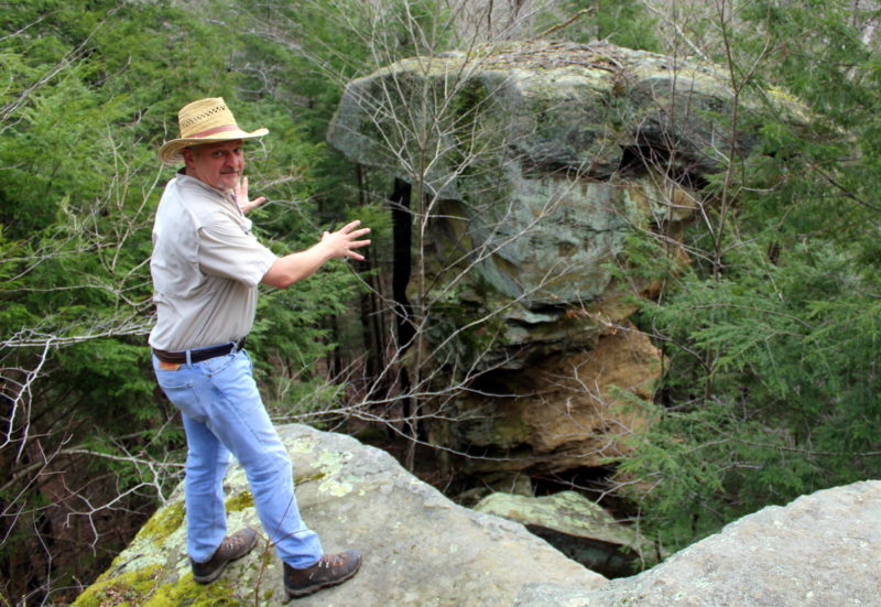
Why was it so-named? Rock formations such as this are commonly called tea tables, because they are very like tea tables, which aren’t so common themselves anymore. They are formed when layers of soft rock erode from beneath tougher upper layers. You might discern in the photo that the larger gray anvil of sandstone on top is more angular and more sharp-edged, because it is composed of harder rock. Beneath it, the column is composed of loosely consolidated rock which has become powdery, gritty, and smooth edged. In a few thousand years, if no other forces act upon it, the column will weaken and the rock will fall, tumbling into the valley of Trace Fork below.
Why is called the “Devil’s” tea table? Europeans often attributed supernatural origin to such unusual geographic features, whether or not they actually considered such forces to be malevolent. I assume most did not literally believe the devil had been at work here, though I’m sure someone with a better sense of history and place-names can verify or discount my assumption.
Many such features across the continent and throughout West Virginia have been so named. I know of two other Devil’s Tea Tables in West Virginia, in Wirt and Ritchie counties. There are certainly many tea tables, a type of pedestal rock, throughout West Virginia, and I can guarantee that I’ll be visiting more throughout the coming years.
The tea table is easy to find. From the old Kanawha Turnpike in South Charleston, follow Spring Hill Avenue south into Little Creek Park. Once inside the park, follow the park road to a left turn onto Harold Bishop Drive, which parallels the Soapbox Derby Racetrack. At the foot of the hill below the track, a small gravel parking area that accommodates about five cars fronts the road on the right. A trailhead map there should act as a good waypoint, though the trail entrances are not otherwise marked.
The Loop Trail along which the tea table is located leads off across a small open area to the left of the map and returns after encircling a ridge to meet the road across from the parking area. The trail is well-tended and reasonably level, though it is narrow in places and will be muddy after a rain or snow. Once at the tea table, more energetic hikers will be able to scramble around the base of the rock and onto the low cliffs that overlook it.
For more information of Little Creek Park, contact the City of South Charleston Department of Parks & Recreation.
Map showing location of Devil’s Tea Table
[mappress mapid=”312″]