MOUNT HOPE, W.Va. — Due to its remarkable fertility, the valley of Dunloup Creek in south-central West Virginia was once called by settlers “Egypt.” But pioneers discovered something even more remarkable when they arrived—a prehistoric ruin built by an earlier culture, and only a few recollections of the ancient stone works survive.

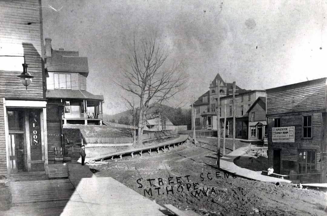
The legendary ruin stood near what’s now the center of Mount Hope, West Virginia, a small but well-preserved city of nearly 1,000 residents near the New River Gorge National Park and Preserve. Once a coal-ming boomtown, it’s now a quiet residential community with a touristy edge.
In the late 1800s, its growth obliterated the fort, yet some early sources say its stones may have been used in the foundations of early wooden buildings and later-built brick and stone structures. This means they may still be present!
Local historians are considering the mystery of what became of the stone, some of which might have been used in the city’s historic public walls, built during the Roosevelt New Deal era.
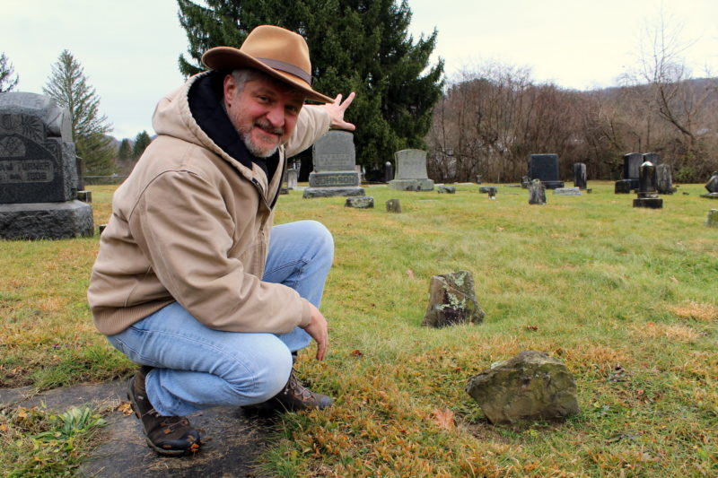
“We’re interested in discovering more about Mount Hope’s prehistory,” Carrie Kidd said while chronicling events for the Mount Hope Landmarks Commission. “The city’s recent history is well documented, but there’s a lot to be discovered about what happened here before Europeans settled.”
The fort figures prominently in early histories of the region, Kidd says, though residents today are far more familiar with its industrial past. Its mines exported more coal than all others on the Chesapeake & Ohio Railroad in the early 1900s, and this boom is apparent in the city’s national historic district.
Perhaps one of the best sources for information on the fort was assimilated by L. Neil Darlington in his 1988 book “Cabins of the Loop and Environs of the southern half of Fayette County, Virginia (now West Virginia).”
Darlington was able to pull together the works of many local historians to paint a picture of the valley in 1805 when William Blake settled what became Mount Hope.
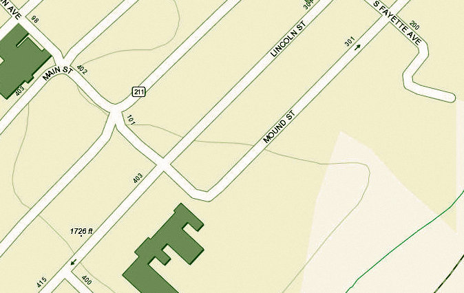
“One hundred years ago, there was a row of mounds where the highway passes through the city,” Darlington wrote.
“A map of Warner Town, which was a part of Mount Hope, shows under date of 1901 a thoroughfare named Mound Street running parallel with the railroad and lying south of Sugar Creek. William Blake’s original survey of 1809 had its beginning on a round knoll that may have been an earth mound.”
Archaeologists now know that mound-builders inhabited West Virginia as early as 1000 B.C., building small villages and raising small ceremonial mounds in small valley areas such as those along Dunloup Creek and establishing larger villages and larger mounds in larger valleys, such as that of the Kanawha.
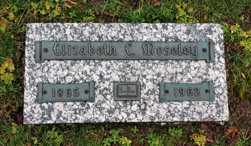
But the purpose of stone works such as the “fort” are less well known. Darlington described the site in some detail, much of which appears to have been based on research by historian Shirley Donnelly. In 1960, Donnelly interviewed Elizabeth Mosley, then 95 years old, regarding her memories of the landmark.
“The fort was situated a few rods east of the row of mounds and just behind the present cemetery, a portion of the site having been cut away by the railroad grade.
“It was a large, walled structure, circular in form, and constructed of native pick-up stone that was said to be well matched and fitted. The walls were about ten feet high and three feet thick. The earthen floor of the enclosed space was considerably lower than the surface of the ground on the outside. This was noticeable when, upon entering the fort, one had to step down on the inside.
“No record of the area or diameter of the circular fort is available, but some idea of its size and capacity may be deduced from the traditional account of activities there during an Indian alarm when the fort furnished a refuge for two families, a horse, two cows, a flock of chickens, and a pack of hounds. The anticipated attack never came, however, probably to the great relief of the refugees.
“This is the word-picture of the old Indian fort as recounted by a lady ninety-two years of age (Elizabeth Mosley) who, as a small girl, played inside the fort which stood in the yard of her grandfather’s home.”
Darlington also recounted a slightly earlier history of the fort in the late 1700s when Native American groups still traversed the area — before the 1795 Treaty of Greenville, after which most tribes formally withdrew their claims to the region.
Until the treaty was signed, settlers in “the Loop,” which Darlington and other defined as the adjoining regions of Loop Creek and Dunloup Creek, lived in fear of attack from members of hostile tribes from beyond the Ohio River.
“The use of the structure as a fort, or refuge for Loop campers in time of threatened attack by Indians, was mentioned above. In the early 1800s, it was referred to as a camp. William Blake, the first permanent settler at Mount Hope, camped in it while building his cabin on his arrival there in 1805. Previous to that, a family named Levisee, or Levacy, camped there. Early land entries, using the structure as a landmark, called it the Rock Camp and, again more specifically, Levisee’s Camp.
“We know that the structure was used as a lodging by the Levisees in the early 1800s and probably in the 1790s, when Shawnees or other raiders from across the Ohio made life hazardous in the Loop. Besides the Levisees, other Loop dwellers such as the Arbuckles from the Oak Hill area (they had given their name to Arbuckle Creek before 1795) may have shared the protection and defense of the fort in time of danger.
Read also: Ghost town hidden in W.Va. may soon be accessible to hikers
But what was the ruin? Darlington proposed that it was a fort built by early European hunters and fashioned from rocks recycled from prehistoric stone mounds there:

“The advantages of this type of domicile for this period in the Loop’s history are readily perceived. The process of converting a stone mound into an impregnable habitation was simple, requiring no tools, no transportation, no skilled labor.”
But the “fort” was not the only stone ruin in the area for which no explanation has been accounted. Stone walls famously mounted the flanks of Armstrong Mountain 15 miles north of Mount Hope and the origins of a similar stone enclosure near Beaver, 10 miles south of Mount Hope, are now being debated.
Archaeologists who explored the Armstrong Mountain walls concluded their purpose was ceremonial — a conclusion drawn on the lack of any other explanation. Sigfus Olafson, Joseph W. Inghram, and Edward V. McMichael wrote in 1972 that the walls were not defensive and not intended as enclosures:
“This then leaves the possibility that these structures may have had some ritualistic or ceremonial significance in the life of the people who built them. However, this is only supportable by virtue of the fact that other explanations are inadequate and are eliminated.”
Similar stone structures have been found elsewhere in the Appalachian Mountains, including the Old Stone Fort in Tennessee.
What became of the ruin? Darlington in his 1988 book claims that it had been dismantled in the 1880s, just before mining operations were established near Mount Hope at MacDonald.
“It stood there for seventy years after it was last used as a human lodging. Children played inside the ruins. Boys satisfied their adventurous urges by scaling its vine-covered walls with whoop and halloo. Eventually the crumbling ruin grew dangerous, and about one hundred years ago, it was razed and the stones utilized for building foundations.”
We may never know whether Darlington is correct in his assumption that the stones were recycled in nearby foundations. Many stones that would have been used could have been moved and reused repeatedly as the village became a town and the town a city.
Archaeological work at the site has never been performed, at least not so far as is publicly known. As a result, it could be years before archaeologists conclude what purposes the fort and other walls built in the area might have served. If they ever do.
Legend of Painted Trees and Indian warpath based on truth
Most folk who live in the winding valley of Paint Creek in West Virginia have heard the legend — that the valley had been the route of an ancient warpath, and that warriors had celebrated their battles by painting trees along the route a bloody red. According to one archaeologist, the late Sigfus Olafson, the tales were true. Olafson contended that the route was among the most important in the Appalachian wilderness and that warriors painted the trees and held war dances there. Read the full story here.
Sign up to receive of FREE copy of West Virginia Explorer Magazine in your email weekly. Sign me up!