
SUMMERSVILLE, W.Va. — Historians in central West Virginia are preparing to commemorate the mysterious site of the crash of a remarkable military aircraft — a wood-winged bi-plane sent to bomb striking miners during the infamous Battle of Blair Mountain in 1921.
The plane about which relatively little was publicly known was coincidentally the first U.S. aircraft to drop a bomb on a battleship in a mission under the direction of Brigadier General Billy Mitchell, the father of the U.S. Air Force.
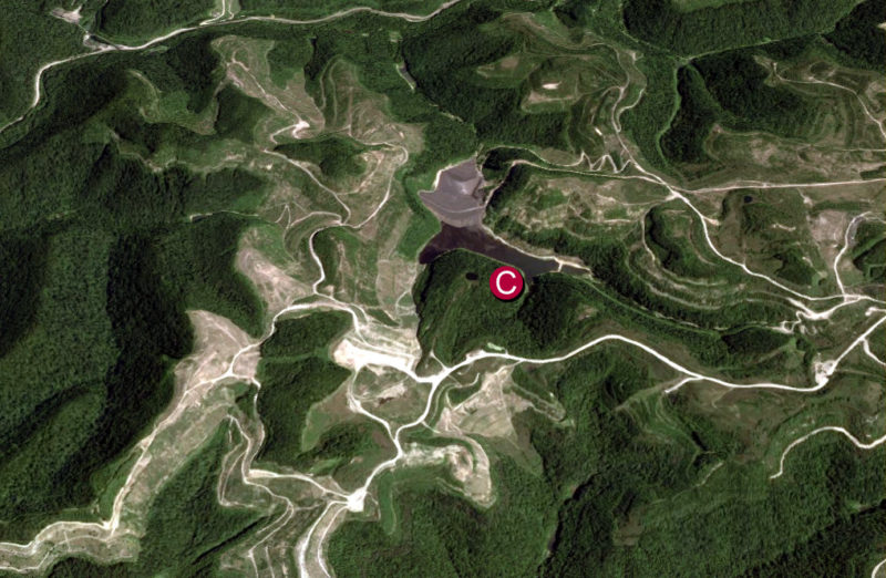
Remnants of the aircraft may linger among mountains so rugged that the daughter of a Cherokee chieftain fled there in the early 1800s to escape the Trail of Tears, though the site is now surrounded by one of West Virginia’s largest surface-mine complexes.
“It’s a fascinating history, and we’re hoping to draw attention to the site by raising a historic marker nearby,” says Ken Summers, a member of the Nicholas County Historic Landmarks Commission.
Summers and other commissioners have been working to identify the site and clarify its history, which is not widely known beyond Nicholas County, where photos of the aircraft, a 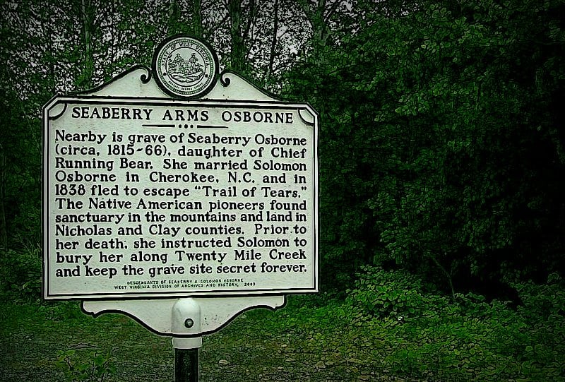 Seaberry Osborne marker[/caption]
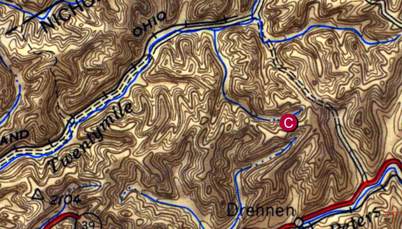
Other historians and government officials have reported finding remnants at a site, described as being in the second left-hand hollow down from the head of Sugarcamp Branch, a tributary of Twenty Mile Creek. Twenty Mile Creek is legendarily the mountain stream along which the body of Seaberry Arms Osborne was secreted in the 1830s.
According to the tale, Seaberry, a daughter of Chief Running Bear, fled the Trail of Tears in Cherokee, N.C., with her husband, Solomon, in 1838, and sought sanctuary in the mountains near the common border of Clay and Nicholas counties. According to a historical marker near the mouth of the creek, “Prior to her death, she instructed Solomon to bury her along Twenty Mile Creek and keep the gravesite secret forever.”
Read also: Ancient stone walls in Kanawha Valley more than an old timer’s tale; Pedal-train excursion leads tourists into remote central W.Va.
Ironically, the upper watershed of the creek became one of the most mined landscapes in West Virginia. Thousands of acres of mountaintop were mined through the 1970s, ’80s, and ’90s, and the idea that Solomon’s grave or the site of the crash could remain seemed improbable.
“But the crash site is still there, as amazing as that might seem,” Summers said. “Amid all of that, there’s still a small patch of woods that hasn’t been touched, and that’s where it crashed.”
Summers said permission would now need to be granted to reach the site as roads into the area are gated by coal mining companies.
Though it’s not likely that the site will be practically accessible in the near future, Summers says that at least the commission hopes to work with the state to install a roadside marker so visitors might be reminded that such a seemingly remote area is connected to a much more expansive history.
The crash site is located some 30 air-miles north of the New River Gorge National Park and Preserve.
Sign up to receive a FREE copy of West Virginia Explorer Magazine in your email weekly. Sign me up!
Do we know for sure if it’s still there? I know a guy who works at the mine and he says the area where it’s supposed to be has been mined. I hope it’s not true. I’ve wanted for a good while now to go in there and try to find it. I love old WW1 era planes and the idea that one could be sitting 10 or 12 miles from me is fascinating. I’ve always wondered how much is still there since it was mostly wood and the other pilots said it caught fire in the crash so I wonder what survived and might still be recognizable. I don’t even know how to go about trying to get permission to go out there. Stop at the office and tall to them I guess?