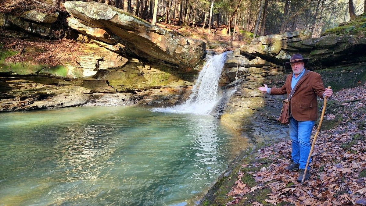
CHARLESTON, W.Va. — Tucked away in a wooded gorge near the West Virginia Capitol, one of the highest waterfalls in the region also powered one of its first mills. However, its history had faded into obscurity until a rare map led historians to a remarkable manuscript.
Though the falls and mill were the source of the name “Mill Creek,” a tributary of the Elk River, finding information on its history was a chore, according to historian David Sibray, who is also publisher of West Virginia Explorer Magazine and a real estate agent who often works with remarkable properties.
“We knew that the waterfall and mill were historically important, but I couldn’t find mention of it in any of the better-known history books,” Sibray said.
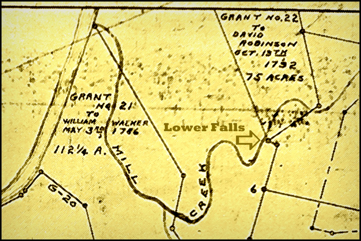
“But at the state archives, I found a property map I’d never seen with a boundary and a corner that was clearly at the falls. It was designated as a grant conveyed to David Robinson in 1792. That’s early! Charleston wouldn’t be chartered until 1794, and the Shawnee wouldn’t relinquish their claim to the area until 1795.
Sibray called on Earl Fridley, a historian specializing in the Elk River region. He recognized the name and began connecting the dots.
Fridey said Robinson was a justice of the first court of Kanawha County and a founding father of the county and the settlement at Charles Town, which would become Charleston in 1819.
Armed with the knowledge, he performed an exhaustive search of the Internet that pulled up a surprising document — a strange notebook penned by Robinson between 1791 and 1803.
Fridley said he was so shocked by what he’d found that he was initially unsure about the connection: “Could this have been the David Robinson we were looking for?”

“There was some question about which David Robinson was which,” Fridley said, “but the more I learned, the more sure I became that this was our guy.”

Fridley found that the notebook was in the possession of Ian Brabner, a Delaware bookseller who described it as remarkable.
“Notably,” Brabner wrote in his description of the manuscript, it included “religious observations and an extraordinarily vivid recounting of a dream Robinson had of his own death. It sheds light on his struggles with faith and his religious beliefs concerning salvation.
“Just over a month later, on August 1, 1803, Robinson wrote a 17 ¼-page Biblical proof of redemption. It transitions deftly to a series of doctrinal questions, questions that Robinson both poses and answers. This may have been his response to the revelation received in his dream as transcribed above: ‘The Scriptures were God’s own word and not to Doubt any part of them.’ ”
Sibray contacted Brabner, who confirmed the manuscript and the author, noting that Robinson had been a genuine American pioneer — “an explorer, surveyor, land agent, and Freemason.”

“This is most extraordinary,” Brabner wrote to Sibray. “This is your man, and the transaction appears in his hand within this manuscript notebook.”
Possibly born in 1733 in Saint Peters Parish in Maryland, Robinson had moved on from Charleston to explore regions west of the Allegheny Mountains before dying in 1806 in Kentucky, Brabner said. “He lived for a number of years in Gallipolis [Ohio] in the Northwest Territories.”
In 1805, he wrote a letter to President Jefferson providing an account of his personal explorations of the Missouri River and the Louisiana Territory. Brabner added that “Robinson’s son, John Hamilton Robinson, would become a spy, map publisher, doctor, and explorer with Zebulon M. Pike.”
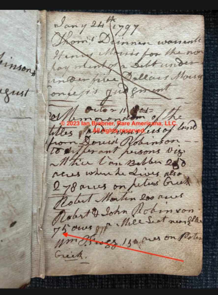
In a photograph of a page from the notebook, Brabner notes that Robinson recorded the purchase of the tract in question: “75 acres on Mill Seat near Elk.”
Sibray says records appear to grow sparse after that, though clearly, the “mill seat” was an important location. The stream flow remains significant in late summer when other water courses may run dry.
“Mill Creek flows year-round, and the same cannot be said for many other streams near Charleston. Given the height of the drop at the falls, the mill there would have been one of the most important in the area, though little documentation has appeared thus far.”
During the Civil War, when Confederate troops occupied Charleston, Sibray says a band of rebel soldiers attempted to commandeer the miller’s horses. According to a local legend, the miller hid his string in caves in the surrounding gorge.
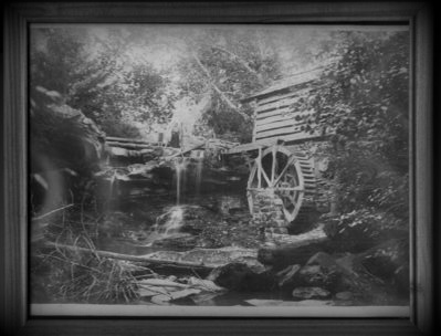
Many mills were likely flooded out and rebuilt at the falls over time, though only one photo of a mill there is known to exist. Some worked stones are located near the falls, likely remnants of a mill foundation, while another group of stones are located near what’s supposed to have been the miller’s house.

When railroads penetrated the area in the late 1800s, the value of gristmills began to wane as cheap white flour milled elsewhere became available. Yet, the falls and the scenic gorge around them remained a favorite hiking and picnicking spot.
However, its popularity would not endure, and it would begin fading from the public’s memory. In 1939, Charleston businessman Edward F. Kotch began assembling properties in and around the falls to create a retreat.
In the mid-1960s, the property was again recognized for its beauty when state officials began investigating the widening of Mill Road as a highway. The W.Va. Dept. of Natural Resources then announced that they were considering the falls and gorge for the location of a roadside park that would adjoin an expanded road.
In an article that appeared in an issue of a conservation magazine, department officials referred to the site as a “Shangri-La,” and state officials encouraged Kanawha County officials to preserve the site as a park. State officials had decided to decline to widen the Mill Road and would route the highway outside the property.
Once the highway, now known as Greenbrier Street, was established, Mill Road fell out of use and was renamed Old Mill Creek Road. The portion of the road through the property was abandoned and is now gated. Behind the gate, its stewards have carefully preserved the scenic landscape. Only a few locals know of the site.
Its owner, Charleston chiropractor Rob Roberston, contracted Sibray and Foxfire Realty to market the property at $950,000, which triggered Sibray to study the site and its resources. In the process, Sibray also discovered the presence of a small Native American mound in nearby Pinch that had escaped public notice.
“Though seemingly remote, this amazing tract has peculiar advantages,” Sibray said. “It’s a drive of less than five miles from the state capitol and Yeager Airport, and it’s only a stone’s throw from Coonskin Park and the proposed extension of the Elk River Trail.”

“Now more than ever, this 16 acres has as much potential as it once did when it was among the most important locales in the valley near Charleston.”
Sibray said he had invited local historians to visit the property to determine what other aspects of its history might be uncovered. The property is otherwise private and gated.
For more information on the property, visit “Mill Creek Falls and Gorge.”
Sign up to receive a FREE copy of West Virginia Explorer Magazine in your email weekly. Sign me up!