
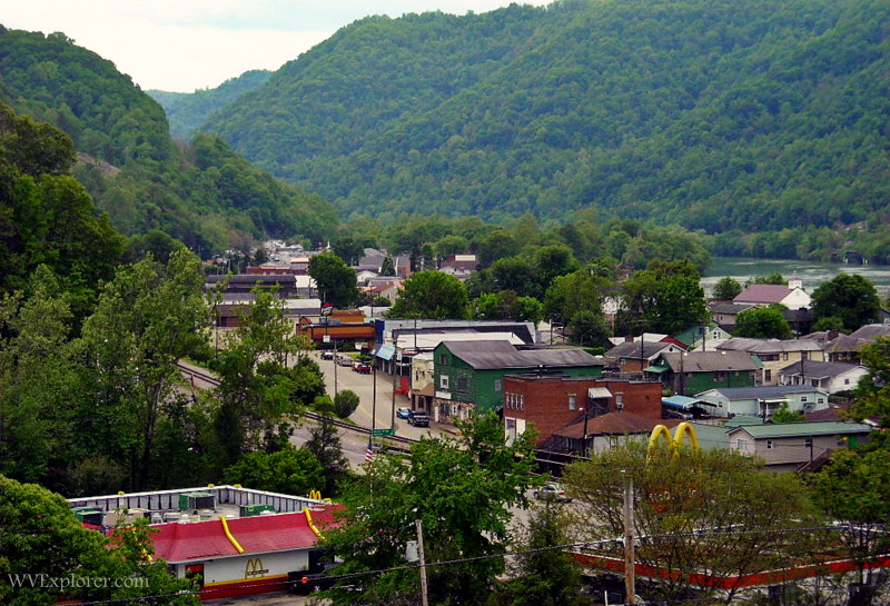
Smithers, West Virginia, is a historic coal and river community on U.S. Route 60 approximately halfway between Charleston and New River Gorge National Park and Preserve. Set along the Kanawha River opposite Montgomery, the small city is also becoming part of an emerging outdoor-recreation corridor known as the River Cities.
The city lies about 10 miles downstream from Gauley Bridge, where the New and Gauley rivers join to form the Kanawha. U.S. 60 through Smithers follows the Midland Trail National Scenic Byway, an ancient travel corridor that later became a principal highway across southern West Virginia.
Most of Smithers is located in Fayette County, though a small portion extends into Kanawha County. The city had 754 residents at the 2020 census, a fraction of its population during the height of the coal-mining era.
Map of Smithers, West Virginia
History of Smithers
Smithers takes its name from James Smithers, an early settler who lived near the mouth of Smithers Creek, which enters the Kanawha River here.
Long before the modern city developed, the upper Kanawha Valley served as a natural transportation corridor through the Appalachian Mountains. Indigenous trails followed the valley, and the route later became part of the James River and Kanawha Turnpike, an important 19th-century road linking western Virginia with eastern communities.
The road later became part of the Midland Trail and, in 1926, U.S. Route 60. Before Interstate 64 was completed, Route 60 was one of the principal east-west highways across southern West Virginia.
Coal transformed the valley during the 19th and early 20th centuries. Coal and Cannel coal were discovered near present-day Cannelton, immediately upstream from Smithers, in the 1840s. Mining expanded as railroads reached the upper Kanawha Valley, connecting its coalfields with distant industrial markets.
Smithers was incorporated in 1938 by combining six neighboring coal camps—Carbondale, Cannelton, Smithers, Oakland, Longacre, and Harewood. These settlements had developed around mines, railroads, and related industries along the Kanawha River and Smithers Creek.

By 1940, the newly incorporated city had more than 2,200 residents, reflecting the much larger population the coal industry supported at the time.
Italian heritage in Smithers
Immigration played an unusually important role in the development of Smithers and the surrounding upper Kanawha Valley.
During the late 19th and early 20th centuries, thousands of European immigrants entered West Virginia’s coalfields. The Smithers area drew a particularly large Italian population, including immigrants from southern Italian regions such as Calabria, Campania, and Sicily.
Smithers and the nearby communities of Boomer, Harewood, and Longacre formed the greatest concentration of Italian immigrants in West Virginia. Many initially worked in coal mines, but immigrants and their descendants also established businesses, churches, and families that became an enduring part of the upper Kanawha Valley’s culture.
One Italian immigrant who lived in Smithers was Giorgio Soddu, later known as George Sodder. Born in Sardinia, Sodder immigrated to the United States as a teenager and eventually settled in Smithers, where he worked as a driver and established a trucking business.
There he met Jennie Cipriani, another Italian immigrant. They married and later moved to Fayetteville, where the family became nationally known after five of their children disappeared following a Christmas Eve fire in 1945. Their fate remains one of West Virginia’s best-known unsolved mysteries.
Smithers is working to preserve its coal-camp heritage through plans for a Coal Camp Heritage Museum and visitor center dedicated to the people and communities that shaped the modern city.
Smithers and the Kanawha River
The Kanawha River is Smithers’ defining geographic feature.
It begins approximately 10 miles upstream at Gauley Bridge, where the New and Gauley rivers converge. From there, the Kanawha flows past Kanawha Falls and through the narrow mountain valley at Smithers before continuing northwest through Charleston and eventually joining the Ohio River at Point Pleasant.
For generations, the river, railroad, and highway shared this narrow transportation corridor. Coal and other industrial products moved through the valley by rail and water, while communities developed on the limited areas of relatively level land between the river and surrounding mountains.
Today, Smithers increasingly looks to the river as a recreational rather than industrial asset. Community redevelopment efforts have included plans for improved river access, trails, parks, and facilities for paddlers and other visitors.
Smithers and Montgomery—the River Cities
Smithers and neighboring Montgomery face one another across the Kanawha River and increasingly promote themselves together as “the River Cities.”
The Earl M. Vickers Memorial Bridge connects the communities. U.S. Route 60 follows the Smithers side of the river, while WV Route 61 serves Montgomery.
The two cities share a history rooted in coal, railroads, and industry, but community-development efforts are increasingly focused on outdoor recreation, tourism, and their location between Charleston and the New River Gorge.

Montgomery also has an Amtrak station immediately across the river from Smithers. The station is served by the Cardinal, which operates between New York and Chicago by way of Washington, D.C., Charlottesville, White Sulphur Springs, Charleston, and other communities.
River Cities walking and biking
The River Cities Urban Walking Trail provides an opportunity to explore Smithers on foot.
The approximately two-mile route begins near the Smithers Gateway Center and City Hall and was developed as part of a larger effort to establish interconnected walking and bicycling routes in Smithers and Montgomery.
Additional plans have called for improvements at Oakland Riverfront Park and expanded access to the Kanawha River, including facilities intended to serve paddlers and boaters.
These projects are part of a broader effort to transform former coal and industrial lands into recreational assets and connect the River Cities with the rapidly growing outdoor-recreation economy surrounding the New River Gorge.
Midland Trail National Scenic Byway
U.S. Route 60 through Smithers is part of the Midland Trail National Scenic Byway, one of West Virginia’s classic driving routes.
Traveling east from Smithers, Route 60 follows the Kanawha River through a particularly scenic section of the upper Kanawha Valley. The highway passes Kanawha Falls and Cathedral Falls before climbing through the mountains toward Hawks Nest State Park, Ansted, and the New River Gorge.
Westbound, Route 60 follows the Kanawha toward Charleston.
The route’s importance predates the automobile. Portions follow an ancient travel corridor that became part of the James River and Kanawha Turnpike and later the Midland Trail. U.S. 60 was established through the corridor in 1926 and remained one of southern West Virginia’s principal highways until the completion of Interstate 64 shifted much long-distance traffic away from the older road.
For modern travelers, that bypass has helped preserve much of Route 60 as a scenic journey through historic communities, river valleys, and mountain landscapes.
Things to do near Smithers
Smithers is well positioned for exploring attractions along the upper Kanawha River and Midland Trail.
Approximately 10 miles east, Kanawha Falls stretches across the Kanawha River near Gauley Bridge. Unlike many mountain waterfalls, it is a broad, river-wide ledge you can view from U.S. Route 60.
Nearby Cathedral Falls plunges approximately 60 feet down a tributary beside Route 60 and is among the most easily accessible major waterfalls in West Virginia.
Farther east, Hawks Nest State Park overlooks the New River Gorge and offers scenic overlooks, hiking, and seasonal recreational activities. Continuing toward Ansted and Fayetteville leads into New River Gorge National Park and Preserve, where hiking, climbing, whitewater rafting, mountain biking and sightseeing are among the principal attractions.
Travelers following Route 60 can therefore use Smithers as part of a scenic journey linking Charleston with the waterfalls and mountain landscapes of the New River Gorge region.
Mammoth Preserve
A major outdoor-recreation project is developing in the mountains near Smithers and Montgomery.
The West Virginia Land Trust’s Mammoth Preserve encompasses approximately 5,000 acres of former mining and forest land in eastern Kanawha County. The project is intended to restore previously disturbed lands and streams while eventually providing opportunities for outdoor recreation.
Plans envision trails and other recreational uses that could complement development in Smithers and Montgomery and help connect the upper Kanawha Valley with the broader outdoor-recreation economy of southern West Virginia.
The preserve remains under development, and visitors should check current access information before planning a trip.
Where is Smithers, West Virginia?
Smithers is located along U.S. Route 60 and the Kanawha River in southern West Virginia. It is approximately 30 miles southeast of Charleston and roughly halfway between the state capital and the principal visitor areas of New River Gorge National Park and Preserve.
Gauley Bridge is approximately 10 miles upstream, while Montgomery is directly across the Kanawha River.
What county is Smithers in?
Most of Smithers is in Fayette County, though a small portion of the city extends into neighboring Kanawha County.
This location places Smithers near the meeting point of two regions: the Charleston and Kanawha Valley area to the west and the mountainous New River Gorge region to the east.
What is Smithers known for?
Smithers is historically known for coal mining, Italian immigration, and its location along the Kanawha River and Midland Trail.
The modern city also serves as one of the River Cities with neighboring Montgomery and is pursuing outdoor recreation, river access, and heritage tourism as part of its economic redevelopment.
Why did so many Italians settle around Smithers?
Coal companies recruited large numbers of immigrant laborers during the rapid expansion of West Virginia’s mining industry in the late 19th and early 20th centuries.
The upper Kanawha Valley became particularly important for Italian immigration. Smithers, Boomer, Harewood, and Longacre developed the largest concentration of Italian immigrants in West Virginia, and their descendants became an important part of the region’s cultural identity.
How far is Smithers from New River Gorge National Park?
Smithers is approximately a 30- to 40-minute drive from many destinations in the northern New River Gorge region, depending on the route and destination.
Traveling east on U.S. Route 60 also provides one of the most scenic approaches. The route passes Kanawha Falls, Cathedral Falls, Gauley Bridge, Hawks Nest State Park, and Ansted before reaching the U.S. 19 corridor near Fayetteville.
Are there waterfalls near Smithers?
Yes. Two notable waterfalls are located about 10 miles east of Smithers along U.S. Route 60.
Kanawha Falls extends across the Kanawha River downstream from Gauley Bridge. Cathedral Falls, nearby, plunges approximately 60 feet beside the highway and requires only a short walk to view.
Several additional waterfalls are farther east in the New River Gorge region.
Is there passenger train service near Smithers?
Yes. Amtrak’s Montgomery station is immediately across the Kanawha River from Smithers.
The station is served by the Cardinal, which travels between New York and Chicago through Washington, D.C., Virginia, and West Virginia. Travelers should consult Amtrak for current schedules because the Cardinal does not operate daily.
How far is Smithers from Charleston?
Smithers is approximately 30 miles southeast of Charleston. The drive generally takes about 40 minutes, depending on traffic and route.
U.S. Route 60 provides the scenic route between the communities along the Kanawha River, while other highway connections provide faster alternatives for some trips.
Where can visitors stay near Smithers?
Lodging within Smithers itself is limited. More accommodations are available toward Charleston and in the New River Gorge region, particularly around Fayetteville and other tourism communities. Read also: Smithers (WV) Hotels
Visitors exploring the Midland Trail may also find cabins, vacation rentals, campgrounds, and other lodging throughout the surrounding region.
Regional Information
Smithers is located in the Metro Valley Region in south-central West Virginia near the New River Gorge Region.