


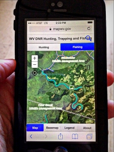
An updated, online interactive map that provides valuable information on hunting and fishing adventures in West Virginia is now accessible on smartphones and tablets, according to Stephen McDaniel, director of the state Division of Natural Resources.
Hunters will find the locations of license agents, check stations, public shooting ranges, wildlife management areas, Class-Q hunter-access roads and hiking trails throughout the state, McDaniel said, and a search option allows the user to focus on specific counties, wildlife management areas, state forests or areas surrounding city and state parks.
Anglers will check fishing information, including fishing and boating access sites, trout-stocked streams, public fishing lakes and float trips. Another tool allows users to measure the length of a stream section they wish to float and to search for specific bodies of water, counties or areas surrounding city or state parks.
“This update to our popular mapping tool is a result of advances in software and DNR’s desire to make hunting and fishing accessible for everyone,” McDaniel said.
“I think recreational hikers or boaters, as well as hunters and anglers, will find this map essential to their adventures.”
Instructions for using the interactive map can be found at mapwv.gov/huntfish/, where outdoor enthusiasts can choose to explore information about hunting and fishing. The map also has a variety of tools and clickable elements with additional information.
The mapping tool also can be found at www.wvdnr.gov, under either the Hunting or Fishing headings or by clicking on the bear icon and looking under “Maps.” An internet or cellular data connection is required to access the map, but a PDF can be printed or downloaded and used on a mobile device when offline.
DNR Wildlife Resources Section personnel gathered and provided the necessary data, design ideas, and contracted with the West Virginia GIS Technical Center to update the interactive map.


