


BECKLEY, W.Va. — A West Virginia lawmaker says he's backing a proposal to attract tourists to two landmarks along I-64 in southern West Virginia—the Eastern Continental Divide and the Phil G. McDonald Bridge over Glade Creek, the highest bridge on the U.S. interstate highway system.
W.Va. Delegate Brandon Steele (R-Raleigh) says he thinks a concept proposed by Gary Godbey to install signage along the interstate at the two locations has cultural and economic merit and hopes to expand on Godbey's concept.
"My staff is currently working on a project that would increase signage regarding these important landmarks and look into the possibility of creating space for tourists to enjoy the landmarks," Steele said.
"It is my hope we will have some legislation drafted for January that will bring together our tourism and highways assets to highlight these important landmarks."
North America's Eastern Continental Divide marks the division between waters that flow east to the Atlantic and those that flow west to the Mississippi.
In West Virginia, the divide follows the summit of the Allegheny Mountains between the basins of the Ohio and the James and Potomac rivers. Godbey, a proponent of educational tourism, proposed in 2018 to install a sign where Interstate 64 crosses the divide.
A similar sign already stands on the divide along Interstate 68 in Maryland, but Godbey says there's good reason to install signage along the divide in West Virginia.
"I'd say most travelers don't realize that there is an Eastern Continental Divide," he said. "Such a marker is worthy of public interest and adds to the Mountain State's appeal."
However, Godbey's efforts to lobby for a sign were rebuffed in 2018 when state Commissioner of Highways Thomas Smith informed U.S. Senator Joe Manchin's office that the sign did not qualify as necessary in West Virginia.
Smith wrote Manchin explaining, "It is the Division of Highways' practice to place signage for geographic features only on the non-expressway facilities throughout the State, which are typically the two-lane roadways."
"It is our practice to provide pertinent travel information of navigational importance to a long-distance driver, as these are the typical users of the Interstate system for which signage is directed."
However, Godbey wonders why Maryland had installed such a sign and why a sign that marks the 38th Parallel on Interstate 64 exists near Mahan, though it is not navigationally important.
He says hopes the initiative to recognize the landmark gains ground now that Smith has been removed from the office by Governor Jim Justice, a move the governor announced Sunday.
The divide generally runs south, following the crest of the Appalachians through Pennsylvania, Maryland, West Virginia, Virginia, and North Carolina to Mount Mitchell. It descends to the Georgia plateau and through the Florida lowlands to Lake Okeechobee.
In West Virginia, the divide follows the high ground southward along the crest of the Allegheny Front across Dolly Sods and over the state's highest point at Spruce Knob to Allegheny Mountain on the state's border with Virginia.
The divide on I-64 is located about three miles east of White Sulphur Springs, West Virginia, in a low gap between a small tributary of Wades Creek in West Virginia and a tributary of Jerry's Run in Virginia.
Before about 1760, the divide represented the boundary between British and French colonies, and the Royal Proclamation of 1763 established it as the western limit of the 13 colonies.
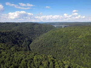
Steel and Godbey also agree the lofty McDonald Bridge near Grandview, West Virginia, which rivals the New River Gorge Bridge near Fayetteville, is another candidate for tourism development.
The Phil G. McDonald Bridge is 176 feet lower than the New River Gorge Bridge, but it is officially the highest bridge in the Interstate System, whereas the gorge bridge is part of the U.S. Highway System.
The bridge crosses the canyon of the Glade Creek 700 feet above the creek. In contrast, the gorge bridge crosses the New River 876 feet above its raging whitewater rapids, where rafting outfitters have famously been guiding trips for decades.
The McDonald bridge is coincidentally also within the bounds of the New River Gorge National Park and Preserve near its Grandview visitor center, a chief focus for tourism in the national park.
Godbey encourages others who would welcome the installation to contact him at gdgodbey@gmail.com.
Sign up to receive of FREE copy of West Virginia Explorer Magazine in your email weekly. Sign me up!


Facebook Comments