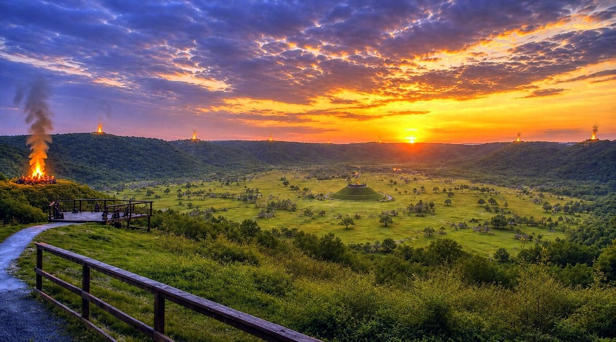
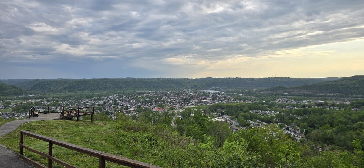
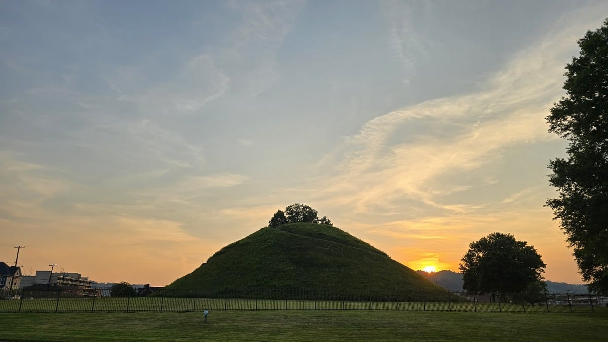
MOUNDSVILLE, W.Va. — Today, visitors standing at the overlook in Grand Vue Park can see the broad basin surrounding Grave Creek Mound, the largest conical burial mound in the United States. From this vantage point, they can perhaps begin to imagine the prehistoric landscape that once occupied the valley.

According to archaeologist Hank D. Lutton, curator of the Grave Creek Mound Archaeological Complex, evidence suggests the mound, one of the largest prehistoric earthen burial monuments in North America, was once part of an extensive network of earthworks, smaller mounds, and other features that stretched across what early settlers called “Grave Creek Flats.”
Yet much of that landscape has disappeared beneath farms, roads, neighborhoods, and industrial development. The surviving mound remains one of the most visible reminders of a prehistoric ceremonial complex that may once have rivaled other major earthwork centers in the eastern United States.
A valley unlike any other
The location itself, “Grave Creek Flats,” is significant. Even today, travelers moving south along the Ohio River encounter a narrow corridor hemmed in by steep hills before suddenly reaching the broad floodplain at Moundsville.
Lutton said the valley’s dramatic opening is one reason archaeologists compare the area to other major prehistoric ceremonial centers. “Even today,” he said, “you come south, and you’re hemmed in, and then suddenly it opens up.”
The same pattern appears at important prehistoric earthwork complexes elsewhere in the Ohio Valley, including sites near present-day Portsmouth and Marietta, Ohio.
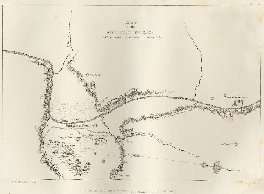
Archaeologists know that Grave Creek Mound was not an isolated monument. Historical accounts from the eighteenth and nineteenth centuries repeatedly describe additional mounds, earthworks, and other features throughout the valley. Unfortunately, many disappeared before they could be carefully documented.
“We have dozens of quotes from early visitors who say there are scores of mounds and earthworks,” Lutton said. “Some of it’s plowed under. Some people didn’t have time to map it all out.”
One nineteenth-century account reportedly estimated that as many as 100 mounds stood within several miles of what was then known as “Elizabethtown,” the settlement that later became Moundsville. While archaeologists cannot verify every historical claim, surviving maps and descriptions indicate that the concentration of prehistoric features was substantial.
The mystery of the ridge-top structures
Among the most intriguing reports are descriptions of circular, stone-lined structures on hilltops and ridges around the basin. They were not necessarily linked to ceremonial bonfires.
Early settlers encountered several examples—features they described as circular, well-like excavations sunk several feet into the ground and lined with dry-laid stone. Because they occupied elevated positions, settlers quickly called them lookout towers.
Lutton believes that interpretation goes beyond what the evidence supports. “From an archaeological point of view, the data is incomplete,” he says. “It’s difficult to know exactly what they were or what purpose they served.”
The absence of mortar would have limited the height of any stone structure built on the sites, making the term “tower” potentially misleading. Lutton prefers to describe them more cautiously as circular, stone-lined features or “wells” in an architectural sense, rather than assuming they functioned as observation towers.
“The one thing we know is that it’s circular and it goes into the ground,” he said. “A tower is very evocative, and it may not have been that.”
Because few of the structures survive and documentation is limited, archaeologists cannot determine whether they were associated with ceremonies, vision quests, funerary practices, territorial markers, or something else entirely.

Were they connected to Grave Creek Mound?
While archaeologists cannot identify the purpose of the ridge-top structures, Lutton believes it is reasonable to suspect a relationship with the broader ceremonial landscape centered on Grave Creek Flats.
The structures appear to have surrounded the basin where the mound complex developed. “I don’t think it’s a wild leap to say they surround the basin where Grave Creek is located,” he said. “So it’s highly likely there is some association.”
At least one prehistoric mound is known to have existed on the summit at Parr’s Point, just south of Overlook Point at Grand Vue Park, further suggesting that ceremonial activity extended well beyond the famous mound itself.
Lutton argues that researchers should broaden their investigation rather than begin with the assumption that the features were military lookouts.
Possible explanations include ceremonial functions, ritual preparation areas, vision-quest locations, or other activities that remain poorly understood today. Indigenous knowledge, he added, may ultimately provide important insights.
More than an Adena story
Grave Creek Mound is traditionally associated with the Adena culture, a mound-building culture that flourished in the Ohio Valley roughly 2,000 years ago. Yet Lutton cautions against viewing mound building as belonging exclusively to a single people.
The construction of mounds and earthworks was a widespread tradition among Indigenous societies across eastern North America. Long before Adena communities built monuments in the upper Ohio Valley, people at sites such as Poverty Point at the mouth of the Mississippi River were constructing massive earthworks.
Using earth to create architecture, ceremonial space, and monuments was a practice that crossed cultural and geographic boundaries. “Mound building and creating landscape architecture is very fundamental to Indigenous Americans,” Lutton said.
The Hopewell culture later expanded many of the concepts seen among Adena communities, constructing larger and more elaborate earthworks across Ohio. Later societies, including the Fort Ancient and Monongahela peoples, continued building mounds.
Historical records even describe Native Americans still using and constructing earthworks in parts of the Southeast during the earliest European explorations, Lutton said.
A monumental landscape designed to be seen
One of the most important insights from modern archaeology is that earthworks were not simply piles of dirt. They were carefully designed features integrated into the surrounding landscape.
Lutton noted that many Adena mounds occupy highly visible locations. Builders often manipulated the natural terrain to increase the apparent size and visual impact of monuments. “They are sited very specifically,” he said.
Archaeological evidence from other regions suggests that Indigenous communities maintained these ceremonial spaces for generations, removing vegetation and periodically renewing sacred landscapes. These findings raise an important question about the prehistoric appearance of the Moundsville basin.
While archaeologists cannot yet prove whether the valley was maintained as open grassland, Lutton questions whether communities would have invested so much effort in monumental construction only to allow forests to obscure the structures. “I would think maintaining the landscape around them so they were visible,” he said.
Similarities to other Ohio Valley earthworks
Although much of the Moundsville complex has vanished, surviving maps and historical descriptions reveal patterns familiar to archaeologists who study other earthwork centers.
Sites in Ohio, particularly around Newark, Chillicothe, Portsmouth, and Marietta, feature combinations of mounds, geometric earthworks, parallel embankments, ceremonial avenues, and astronomical alignments.
Lutton stops short of claiming that Moundsville contained identical features. However, he notes that the surviving evidence points to similar components and organizational principles. “The configurations look similar,” he said.
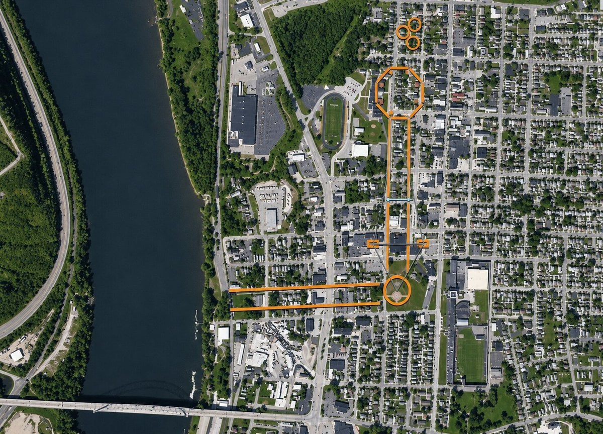
Those similarities suggest that Grave Creek Mound may once have stood at the center of a much larger ceremonial landscape than many visitors realize today.
What remains of a vast complex
Despite extensive destruction, not everything has disappeared.
In addition to Grave Creek Mound itself, several smaller mounds survive in and around Moundsville. Archaeologists know the locations of other mounds that were destroyed in the nineteenth and twentieth centuries, and evidence of village sites associated with the mound-building communities remains.
Lutton cautions against viewing Grave Creek Mound as a lone survivor standing in isolation. “It’s not quite true,” he said. “There are still other mounds around.”
From the overlook at Grand Vue Park, visitors can still see the natural basin that helped shape one of the Upper Ohio Valley’s most important prehistoric landscapes. Much of the archaeology has been lost, but enough remains to suggest that the valley once contained a network of monuments, ceremonial spaces, and earthworks that extended far beyond the famous mound at its center.
For archaeologists, the challenge now is distinguishing documented evidence from local legend while continuing to reconstruct a landscape that was once among the most significant ceremonial centers in the prehistoric Ohio Valley.
Why most of Moundsville’s ancient earthworks disappeared
Unlike Grave Creek Mound, most of the earthworks that once occupied the Moundsville valley did not survive into the modern era. Archaeologists and historians attribute their disappearance largely to two centuries of urban development that transformed the Ohio River floodplain.
When European-American settlement expanded in the region during the late eighteenth and nineteenth centuries, many ancient mounds and embankments were viewed as obstacles to farming, road construction, and later commercial development. Fields were plowed, streets were laid out, and buildings were erected across portions of the valley where prehistoric features once stood. By the time professional archaeological surveys became common, many of the smaller earthworks had already been leveled.
Historical accounts and early surveys indicate that Grave Creek Mound was once accompanied by additional mounds, earthen enclosures, and other ceremonial features spread across the surrounding landscape. Some survived long enough to be recorded by nineteenth-century researchers, while others disappeared before detailed documentation could be completed. The result is a fragmented archaeological record that provides only a partial picture of the original complex.
The survival of Grave Creek Mound itself was not guaranteed. During the nineteenth century, portions of the mound were excavated by antiquarians seeking artifacts and burial chambers. Although those investigations revealed important information about the people who built the mound, they also altered the structure. Preservation efforts undertaken later by the state helped protect the site from the fate that befell many of the valley’s other earthworks.
Today, the mound stands as one of the few visible reminders of a ceremonial landscape that once extended across much of the valley floor. Archaeologists continue to rely on historical maps, early descriptions, excavation records, and modern landscape analysis to reconstruct features that have long since disappeared beneath streets, homes, schools, and businesses in present-day Moundsville.
The grand view from Grand Vue Park
Visitors seeking to understand the prehistoric landscape of Moundsville can gain perhaps the best perspective from Grand Vue Park, which occupies the ridge southeast of Grave Creek Mound. From the park’s overlook, the broad basin surrounding the mouth of Grave Creek can be seen much as it would have appeared to Indigenous peoples who constructed the mound and associated earthworks.
From this vantage point, visitors can better appreciate how the mound once stood within a larger landscape of earthworks, smaller mounds, and ceremonial features that early settlers reported throughout the valley.
Today, Grand Vue Park combines that historical perspective with one of the region’s most developed outdoor recreation destinations. The park features a water park, zipline courses, aerial adventure attractions, hiking trails, RV facilities, and modern event venues.
Luxury cabins and lodge accommodations overlook the Ohio Valley, providing panoramic views of the same landscape that has attracted human settlement for thousands of years. Visitors can spend the morning exploring one of the most significant prehistoric settings in the upper Ohio Valley and the afternoon enjoying amenities that have made Grand Vue one of the northern panhandle’s leading tourism destinations.
About the Grave Creek Mound Archaeological Complex
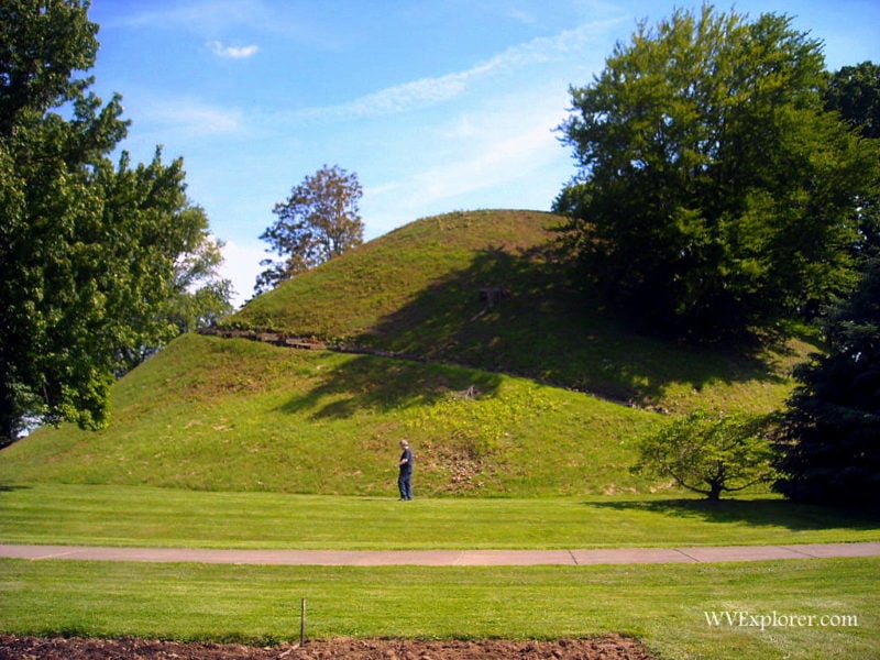
In the valley below Grand Vue, visitors to Moundsville can explore two of West Virginia’s most significant historic attractions within a short walk of one another. The Grave Creek Mound Archaeological Complex, located at 801 Jefferson Avenue, preserves Grave Creek Mound, the largest conical burial mound in the United States and one of the most important prehistoric monuments in North America.
The complex includes museum exhibits that interpret the Indigenous cultures of the Upper Ohio Valley and the site’s archaeological history. Admission to the museum is free, and the complex is open Tuesday through Saturday from 9 a.m. to 4:30 p.m. Visitors may walk the grounds and view the mound throughout their visit.
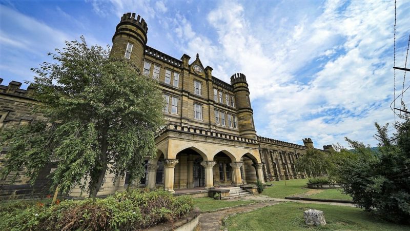
Directly across Jefferson Avenue stands the former West Virginia Penitentiary, a Gothic Revival prison that operated from 1876 until 1995 and is now one of the state’s most visited heritage tourism destinations. Guided historical tours allow visitors to explore cell blocks, administrative areas, and other portions of the prison while learning about its architecture and history.
During the summer season, guided tours are offered Tuesday through Sunday beginning at 9:45 a.m., with tours departing hourly through the afternoon. The penitentiary also hosts twilight tours, paranormal investigations, and special events throughout the year. Together, the archaeological complex and penitentiary offer visitors an opportunity to experience nearly 2,000 years of Ohio Valley history, from prehistoric mound builders to one of West Virginia’s most recognizable nineteenth-century landmarks.
There may be an even larger one at Catawba, WV. It was discovered a few years back. They thought it was just a large hill. Totally untouched, except for few bike trails. Maybe they are trying to keep quiet about it to preserve it. It’s big and covered with large trees.
Criel Mound in South Charleston, WV sits at the center of a ceremonial complex much like the Graves Creek Mound, including stone structures on the ridges surrounding the area. It spans much of the Kanawha Valley and includes a mountain top complex of stone walls on top of Mount Carbon. Those walls are very similar in structure to walls found in NC and Ga.
The Smithsonian opened the mound in South Charleston and found a very unique burial of 11 people. They still have remains and funerary items stored there. They mapped much of the valley, 100 mounds and earthworks. Only 3 small mounds remain.
It’s sad. The Kanawha Valley went from being a sacred ceremonial center that lasted for thousands of years to being known as Chemical Valley in as little as 200 years.
There are a number of mounds north of Point Pleasant along Old Town Creek. To my knowledge, they had been opened many years ago and a man that lived near there had a “museum” of artifacts in his garage in the 1950s and ’60s. However, the garage burned at some point and everything was lost. That was before such things as grave robbing were stopped (and rightfully so).
I remember seeing the mounds when I was young. We fished the creek and explored the countryside as boys will do.
I haven’t been able to find any information about them and wonder if anyone knows of any writings concerning them?
Excellent article. Thank you
They were all murderers and rapist. I have documents from the late 1700s when my ancestors were attacked and butchered for 100 years trying to farm and live here peacefully. Almost Zero indians were peaceful. Why do you think we find millions of arrowhead here? They were fighting constantly…
We then paid them more money than anybody we’ve ever tried to do land deals with in the history of the US. Where are they now? In slums and reserves where they mostly drink and continue to their rich history of violence. This was just another lie we were sold. Similar to slavery. Mostly didn’t happen.
I laugh at majestic paintings of them standing proudly. Lol. They did nothing for this country besides massacre women and children. Drag babies behind horses and slam them off the ground.
When they control what information you receive, you must dig deeper to find truths. Matt walsh youtube, start there.
Or cry and whine when you see this, then go find some reservation and give them all your money for no reason. Its a joke. They continue to lie about the real American history. Its soaked in blood and money. Just like today.