


Many West Virginia rivers have gained notoriety as travel destinations in recent years, largely as a result of their restored post-industrial water quality and because of increased expressway access, but the Guyandotte of the southwestern mountains has lingered in relative obscurity, at least until recently. And that's something I like most about it: from source to mouth, it travels some of the least-known countryside in the Mountain State.
Though I don't hope to detail much of the wonder of its 166 miles here, I'd like to touch on a few highlights, particularly those that regard its prehistory and the return of native peoples to the area. Visitors should be aware that developed tourist destinations are still few and far between, but home-style eateries and neighborly folks are plentiful, and an increase in ATV and off-road vehicle tourism is attracting many new hospitality venues.
Any introduction to the valley would have to include the matter of its naming, the origins of which may never be confirmed. According to some sources, "Guyandotte" may derive from "Wyandot" or "Wendat," a Huron people whose name may mean “island people” or “dwellers on a peninsula.” However, the Wyandot lived among the Great Lakes, far from southern West Virginia and, at nearest, in northern Ohio.
Some historians have speculated that the name may instead derive from the French word "guyana," meaning "scout." The Town of Guyandotte at the mouth of the river was a French settlement, as were others along the upper Ohio River, such as Belpre, Marietta, and Gallipolis. (Read: The Tragic Fate of Guyandotte.)
Others have said it may be a corruption of the name of a French painter named Guyan who visited the area in the 1700s. The river coincidentally sources in the highlands on and near Great Flat Top Mountain in Raleigh County, south of Beckley, along which there is a Guyan Ridge. Many locals also refer to the river as the "Guyan" rather than the Guyandotte.
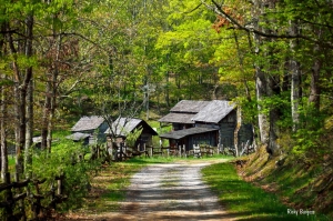
Only a few miles from the upper Guyandotte, on its Cabin Fork, Twin Falls Resort State Park provides visitors an ideal locale from which to explore this upper section of the valley. Even without venturing off the park, guests who overnight in its lodge or cabins or who camp there will find much to do. I often hike to overlooks at Buzzard and Canada cliffs or walk to its waterfalls and restored pioneer farm.
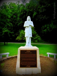
Many of the native inhabitants of the valley — and some say all of its inhabitants — left the area just before permanent European settlement, but by 1760 at least some had returned with Boling Baker and his wife, Aracoma, a supposed daughter of Shawnee chieftain Cornstalk, and they settled an island in the river, Hatfield Island, at present-day Logan.
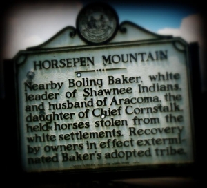
Much of that history is lost in legend. Baker may have been a soldier in General Edward Braddock’s army during its disastrous assault on Fort Duquesne, now Pittsburgh, in 1755 during the French and Indian War. He was evidently captured by Shawnee and accepted into a tribe. In 1870, he led a band of Shawnee to steal horses from the Bluestone River near present-day Bluefield, and during his absence smallpox ravaged the island. He famously stabled the horses atop Horsepen Mountain at the head of Island Creek.
Aracoma's Tale is retold on summer evenings in the amphitheater at Chief Logan State Park, near Logan, on the middle Guyandotte. Chief Logan is one of the region's principal public parks and an ideal year-round destination for hiking and camping vacations. Several guest cabins have also opened at the park this year. Not coincidentally, the Guyandotte Beauty Trail is one of the better-known trails in the park, named for the Guyandotte Beauty, a mint which famously blossoms along the path and elsewhere in moist forests in the Ohio Valley region.
I am not satisfied that all natives had disappeared from the area before European arrival, and I suspect that many remained deep in the forest of the Guyandotte valley, which contains some of the most rugged land in all West Virginia.
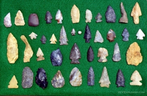
At least two well-known prehistoric sites remain in the valley to attest to long years of pre-European habitation. Along the Clear Fork of the Guyandotte River at Lynco, near Oceana, a series of "petroglyphs" had been discovered by settlers, and for decades they have attracted the attention of scholars, who remain uncertain about their origins or purpose.
In the 1970s an amateur archaeologist speculated that the carvings had been etched by Irish monastics, setting off a firestorm of wild theories that still smolders, though scholars quickly disproved the theory.
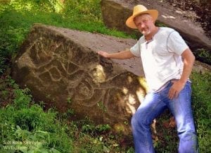
However, at Salt Rock, about 20 miles upstream of the mouth of the river, a truly fantastic archaeological site remains -- the Salt Rock Petroglyphs. Here a series of carvings of strange creatures and even a human figure cover several large boulders. Despite their authenticity and the pleas of the archaeological community, the state has not moved to protect the site, which is located on private property and for now is not publicly accessible.
Throughout the region visitors will come across aboriginal names such as "Logan." Though they honor the region's prehistory, it's worth noting that none have authentic antecedents. The Iroquois orator Logan never lived in Logan County, nor did Oceana, the youngest daughter of Mingo chief Cornstalk, ever set foot in Wyoming County. However, in the 1850s attorney Thomas Dunn English, author of the songs "Sweet Alice" and "Ben Bolt," was practicing law in the region and frequently toured its hollows, propounding that residents adopt native names as a means of attracting investment.
Investment would come soon anyway in the form of coal mining, and though the efforts of English may not have had much economic impact, the names have done much to inspire a romantic interest in the land. Other communities with native names in and near the region include Mohawk, Mataoka, Mohegan, Lacoma, Otsego, Ottawa, Matewan, Oceana, Hiawatha, Naugatuck, and Powhatan — and there may be more I've overlooked.
Soon after the Civil War, coal operators began to establish mines in the area, and by 1900 even the most remote corners of the valley were teeming with miners and merchants.
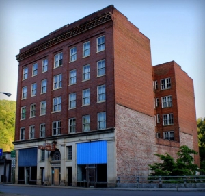
Despite its former isolation, it quickly filled with coal camps as well as sizeable towns in the midst of which elaborate masonry buildings were raised. Along the river at Mullens, Pineville, Gilbert, and Logan visitors may now walk streets that seem more appropriate to the industrialized northeastern U.S. than to mountainous southern West Virginia.
As coal mining dwindles, these historic buildings promise to seem even more strangely placed, though entrepreneurs are searching for ways to rescue what they can and are banking on their ability to attract visitors in future. Many are providing lodging accommodations to serve off-road-vehicle enthusiasts who exploring ATV (all-terrain vehicle) trails near Logan, Gilbert, and Pineville. Others are banking on the river as a destination for kayaking and water recreation. For now, however, the valley remains a domain known to relatively few.
Note: I'd like to thank Lisa Stansel Gravitz for her help writing this article, which was originally published in a condensed form for her publication Daytripper.


Facebook Comments